


Anyone who watched both Battle of Britain and Dunkirk understands which of the two is a better war movie
World War 2 Flight Map
-
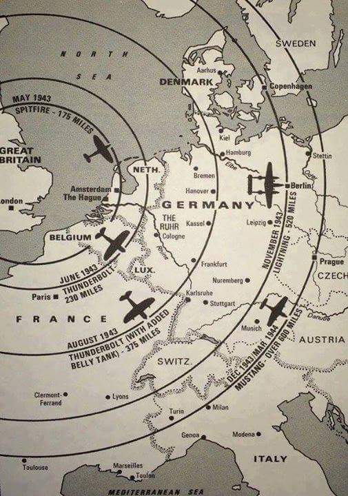
Given the attached map, one has to wonder about flight ranges given in the rules. (As in, wondering how accurate or inaccurate they are.)
In my opinion, it looks like the ranges are about right, but what do you think?
-
The ranges in the attached map look believable. As for the A&A rules – any version of them – I consider the travel ranges of all the units (planes and ships and ground units) to be abstractions more than anything else. There are a couple of reasons for this. In terms of space, the A&A maps are not only distorted (in both size and shape) relative to the geography of the real world, they’re unevenly distorted; in Global 1940, for example, China is highly compressed east-to-west compared to its north-to-south dimensions. In terms of time, a game turn doesn’t represent (as the attached map does) a single airplane sortie but rather a span of several months – and an imprecisely defined one, for that matter. In tactical-level wargames, which operate on a much smaller scale both in terms of time and geography, it’s possible to have meaningful range accuracy, but as far as A&A goes I think that the best that can be achieved is to give units a range that looks vaguely plausible on an impressionistic level.
-
Interesting points.
I do notice that sea zones, at varying differences between games, seem to be either more or less friendly than land zones can be when determining flight ranges.
I think, in regards to Europe, the map lines up pretty well with the rules (in the current rendition of the game). I think in classic it does not line up as well. Just my two copper pieces…
-
@Cmdr:
Interesting points.
I do notice that sea zones, at varying differences between games, seem to be either more or less friendly than land zones can be when determining flight ranges.
I think, in regards to Europe, the map lines up pretty well with the rules (in the current rendition of the game). I think in classic it does not line up as well. Just my two copper pieces…
Then the US figs and Tac Bombers should get to move 6 after T5 or 6
Suggested Topics

