


@GEN-MANSTEIN said in Huge maps:
Possible. I would perfer a slide out drawer of some sort. Then push back in under the dice box. You can make dice box smaller too and have same roll out drawer for sides.
Yes, that’s a good approach too.
“Removed standing army icons on neutrals”
Greetings, new player here but loving it already and I am looking to get a map printed soon. Yours looks amazing. One question though, why the removal of standing army icons on neutrals? Does everyone just memorize with the hours of gameplay how many units would get called up to defend?
Thanks.
First of all thanks for all the kind words and useful feedback! I will take the suggestions I like to the map, but as there are to many views on the map I simply cannot incorporate them all. But if some of the things you like to see don’t make it to the map I publish here, you’re free to send me a PM as I can always look at it for a small fee so you can play on the map you like best.
Volgograd. I’ve been thinking what it should be named instead. Maybe Don-Volga or Don Valley or something like that.
Thanks I’ve learned something new. You’re right about Volgograd being a name that is from the 1960’s. Officially the region itself was called Stalingrad Oblast (or just Stalingrad for short) but to me that looks a bit weird on the board. But most importantly Volgograd is a region being part of the initial setup so I’m hesitant ot change it for that reason alone. But not decided yet what to do :-D
Samara. Whilst not as egregious as Volgograd, this territory and its capital city were called Kuybyshev and Kuybyshev Oblast from 1936 to 1991.
Again something new I learned. As in this case the region was also called Samara before 1936 it seems less of a problem.
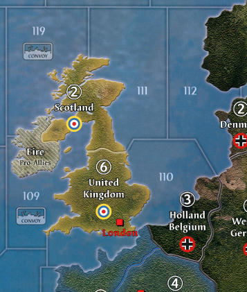
Also, maybe Gibraltar and sz 110 (English channel) could be slighly larger?
More people have pointed this out in our Dutch gaming community (outside this forum) so I’m looking into this at the moment. Although Gibraltar will never be big enough for all scenario’s. The reason for SZ 110 not being larger in the first preview is the fact that I intend to print the fill a bit larger then OOB size. Roughly 225 by 100 cm or 88.6 inch by 39.4 inch, which makes SZ 110 large enough. But I see it would fit if you print OOB size or slightly larger then that
@The:
- While the standing army icons aren’t necessary for the neutrals, my personal preference would be to have the number of units printed on each country, perhaps in a box or triangle and in a contrasting color from the name/IPC value.
If you want those number why not simply keep the standing army icons in tact? I will release a few files that are close to OOB as the changes to the standing army is layer I can switch on or off.
@The:
- Really like what you’ve done to enlarge Holland Belgium and Bessarabia. Wouldn’t mind seeing Gibraltar and SZ 110 a bit larger, if possible.
I haven’t changed Holland Belgium… but Bessarabia is enlarged inspired by Intreprids work on the same map. Gibraltar and SZ 110 are in the making.
@The:
- The eastern border between Kenya and Tanganyika Territory seems a bit muted or possibly thinner, compared to the border west of Lake Victoria…but viewing it again from a slightly different angle, it may just be my tired eyes.
I’ve heard this from more people. The problem with this border is that the surrounding colors are close to the border color itself. I will try to see if I can increase the highlight and drop shadow on this border. Similar visibility issues seem to arise at the border of New South Wales and Victoria.
@The:
- Now for the first of two truly trivial points: While “Johnston Island” is technically correct, the more accurate name is “Johnston Atoll,” IMO. Johnston Atoll is made up of four islands. During WWII, the US had an airbase on Johnston Island and a seaplane base on Sand Island, part of the same atoll.
As Johnston Island is technically correct and part of national objectives (and to ensure I will finish this map shortly) I will leave it as is for now.
@The:
- This goes beyond your map and to the game itself, but I’ve always thought the significant oil resources in Alberta should merit a 2 IPC value for that territory.
I won’t be doing any changes to the actual game play.
One question though, why the removal of standing army icons on neutrals? Does everyone just memorize with the hours of gameplay how many units would get called up to defend?
I would not suggest to remove them at all unless you customize your game a bit. I’ve bought neutral army infantry from Historical Board Gaming that we put on the board during setup. With those infantry in play we simply have no need for the icons any longer. But we do need to have a setup card that holds this information to be able to correctly setup the neutral armies.
Once again thanks for the feedback! I’ve made all suggested changes to the map except for name changes and I would like your feedback on two important changes to SZ 110 and Gibraltar.
SZ 110
I’ve been playing around with different versions of an enlarged SZ 110. So I’ve attached 3 versions below for you to review. Please let me know which one you like best.
Option 1: Intreprids design
Option 2: Steeper angles
Option 3: Border of Scotland - UK rotated
Gibraltar
Next to that I’ve enlarged Gibraltar. Please review the last image in this post and let me know what you think.
SZ 110 Option 1

SZ 110 Option 2
SZ 110 Option 3

Gibraltar Enlarged
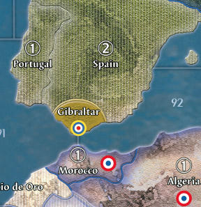
The expanded Gibraltar looks great.
My vote is for Option 3, though they all look good.
Again, well done!
Gibraltar looks great. Another vote for option 3!
I also add a vote for option 3. Love the new Gibraltar (but I already told you that off-site) :-D
Also I like the special surprise.
Another vote for option 3
So option 3 it will be! This option was the logical conclusion moving from 1 to 2 to 3 in the design process.
The map has been printed in different size and they all look great! As soon as I have time I will post some pictures for you and update the file in my first post.
Some last minute adjustments I made:
Made Panama Canal a bit smaller
Enlarged the adjacent to sea zone numbers for better readability
Rename both Volgograd and Samar to Stalingrad and Kuybyshev respectively as suggested by 8thGuards
I’m really happy with how the project turned out and cannot wait to play our first game on the enlarged map (220 by 100cm) next Saturday! Thanks everyone for your input.
Regards,
Joost
I’m looking forward to next saturday.
@The:
- While the standing army icons aren’t necessary for the neutrals, my personal preference would be to have the number of units printed on each country, perhaps in a box or triangle and in a contrasting color from the name/IPC value.
If you want those number why not simply keep the standing army icons in tact? I will release a few files that are close to OOB as the changes to the standing army is layer I can switch on or off.
I think you’ve done a brilliant job. I would definitely be interested in a version which had the neutral standing armies on the map.
However, I will still be looking forward to the conclusion to this project (so I can get a map printed :-D).
Updated first post for my first release of the map. Let me know what you think and don’t forget to send me pics of your printed copy of this map!
Let me know your specific wishes/change request and I might be able to work on them for a small fee.
awesome!
would you mind also sharing the PSD(?) file? or indicate where I can find one?
I’d like to work on a global 42 map version but based on the AAG40 map…
thanks!
awesome!
Thanks mate!
would you mind also sharing the PSD(?) file? or indicate where I can find one?
I’d like to work on a global 42 map version but based on the AAG40 map…
Simply load my png file in Photoshop and you’re good to go. The quality doesn’t get better as the original file was jpeg to begin with.
In case you’re looking for a layered PSD document, that doesn’t exist. The original file was a scan of the board, not a proper design document with layers for borders, country colors, names etc.
Good day, I want to know on what scale it is better to print this map (1m 30cm/ 60cm)?
Or is there a much better scale?
thanks for the reply. did you layer it?
:mrgreen:
I have been keeping a attentive eye on this project. After taking a good look at the map, I wanted to provide some feedback The quality of your work is exceedingly impressive! I am currently shopping around for a printer to bring this to reality. Thanks for all the countless hours you spent on this project and for supporting this community in such a tangible way.
Good day, I want to know on what scale it is better to print this map (1m 30cm/ 60cm)?
Or is there a much better scale?
The original Global 1940 map is around 177cm by 81cm, so I would definitely don’t go below that.
However I do recommend a slightly larger print out at 219cm by 100cm. This really helps with unit placement as every territory is just a bit larger.
But after all it’s up to the size of your table what will fit.
thanks for the reply. did you layer it?
:mrgreen:
Short answer is no. I did make my changes in layers, but most where merged along the way to keep the total file size manageable (just under 1GB)

