I have been playing around with different configurations for a custom table and wanted to note some things I’ve landed on that I really like. A main one thing is having the map mounted so that it can slide around as needed on top of a bigger playing area. My table is 65” x 95” in total with a 5.5” arm rest around the outside and the middle is a recessed neoprene surface. I have the OOB Global map mounted on 1/2” rigid foam with a 1/2” aluminum frame around it. This allows the map to slide up close to whoever’s turn it is, but then be in the middle so both players can roll dice In front of them without disturbing the map and in easy view of the other player. (Plus we like lots of room to roll the bones). This ability to adjust the surface along with a standing height, makes it comfortable for long uses because you can move around more and don’t feel as tied down.
Things I’ve learned and changed from original design - I originally used too big of a frame for the map and mounted it on too high of a foam block (you can see these pictures at the bottom) - it made it hard to see the other player’s dice and the big frame took up too much real estate. My global map is mounted on much thinner foam (the framing is bad, you can see if you look closely) but I also used much thinner aluminum angle for the frame. This gives just enough grip when needing to move the map around (I use furniture slides on the bottom, which glide very nicely on the neoprene) but doesn’t make the whole thing too bulky. Having it an inch or so off the surface keeps the dice off, but isn’t so heigh that you can’t see the other player’s dice rolls. When playing other versions (such as Zombies) the board is much smaller, but it can easily swap in and out on the same table since it can move around where ever it is needed or be pushed aside.
I originally made it normal table height, but found long reaches while sitting were harder and it just felt cramped. Standing height with a bar stool is a great way to have the best of both worlds.
The 5.5” rim around the table itself gives you a nice arm rest that doesn’t interfere with the gaming surface. I’m playing with how to best add some cushion to this part - open to suggestions. Sometimes I just lay a piece of leftover neoprene on it.
Dice bounce nice on the neoprene and stay off the floor. It also feels nice and has enough give to allow things to slide but be picked up easily. Wouldn’t definitely go with neoprene again as a surface covering.
I made the drawers open to the inside of the table so you can stay hunched over the action while accessing and stowing stuff away. 50/50 on whether I would keep this if I were to do it again. If I were doing it again, I might try to build customer drawers form scratch using actual drawer glides, but that was beyond my ability when I first did this, so I just used clear plexiglass boxes with aluminum pulls mounted on them. It’s nice having them clear, and I was happy with how the pulls came out, but without glides they can be a little fussy sliding in and out of their slots.
I originally designed the table so that I could put a cover surface back on top when not in use, but find I don’t really ever do that, so if I were to do it again, I might not mess with that part (I never even finished staining those as you can see in the pictures).
CF362D52-269F-4480-8CBB-08139099138F.jpeg A9E12EA1-66EB-4671-86AC-68C62FD30AD5.jpeg 858DE1F2-030A-4D5A-93E4-70A7D1180ADB.jpeg 8F513EE0-DA37-4BA9-880E-4D5EF7BF431F.jpeg F0188165-757B-4CC1-BF67-5045832283C9.jpeg 2E3CD627-0D31-4121-ACF8-682F9F58A40B.jpeg
Hybrid Terrain Map (wargaming vs trainmodel)
-
Hey, guys…
I will soon be finished with my new table, perhaps you want to have a quick look…
The map is 1,2 x 3,6 meters, the table is 1,25 x 4,5 meters (incl dice trays etc)
The goal is to at least make it playable, esthetics not so much :)
It is a merry mix of train model and war gaming styles + a few puns thrown in (ex.the yellow sub out side the coast of Sweden:)Pic-1: Europe
Pic-2: Looking south from north of Norway, German infantery in Sweden is carrying a panzerfaost btwI still have to mark the sea zones and cover the oceans with water(-effects) + minor detales here and there -> I can post more pics when I am finished if anyone is interested…
Peace!
Jarl Christian / Fenris
-
What a novel idea! Thanks for sharing. How do you find that it affects ease of gameplay? (IPC values, recognizing territory control, etc)
-
Wow! It is clearly a labour of love and will give you immense pleasure whenever you use it.
-
Thanks, guys:)
I haven’t played on the table yet, so i still really can’t say. I mean, looking at it now is a bit different from an actual game (stress, competition mind set ect).
That being said, there is a few obvious things;
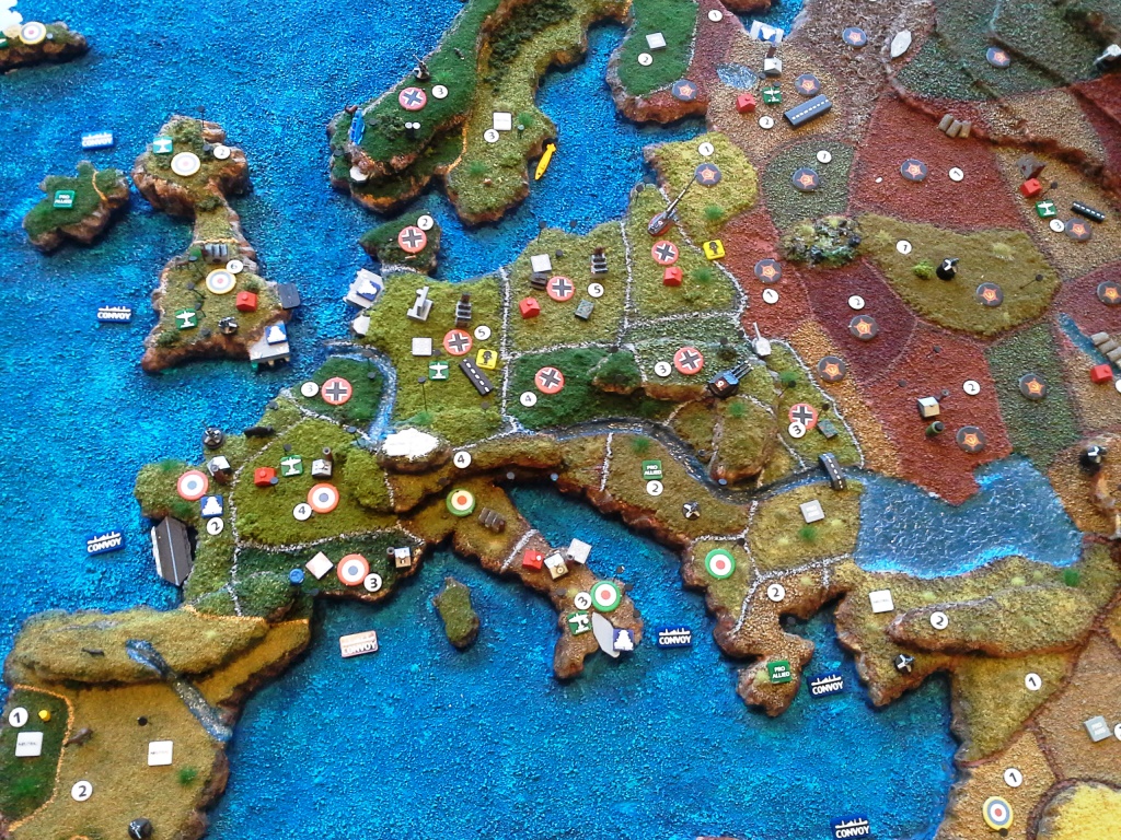
The map is enlarged by 50% but that extra area is in most places lost due to the slope of the continents/land masses (the shores so to speak). But that is why i wanted a bigger map in the first place.
Mind you, a reoccurring theme here is my complete inexperience with painting, modeling and all other craft skill needed to do this project. So i am complete open and frank about this: i just really wanted to do this, and so i did. If you go to any decent war gaming shop or simply youtube, you will find terrains one million times better than mine. But that is ok, at least for me. Its “home made” and it shows, but i feel that has a charm of its own. And not speaking of detail work and finesse, i have made a couple of bloopers that i really could, and should, have avoided, like mounting Iceland up-side down (sorry, my Icelandic friends, hope you don’t get dizzy;)
The territories are quite easy to differentiate; the border is painted in a fairly noticeable color and/or no territory is next to one with the same color. The mountains makes it a bit more difficult to see all territories (or at least which pieces are located there), especially with the Himalayas which is 4 levels high. I think this will play in with the sea zones as well; all though i plan on putting on a 1 cm thick transparent water layer, it might be a bit challenging to notice a low small submarine from a far (if it is places close to the land/shore).
I have glued on (starting) nation markers, when someone takes over a territory the new roundel is simply placed on top of the other. The territory value (IPC income) is perhaps a bit too small, but when i came round to placing them on the map, it was already a bit crowded with other things, so i felt i couldn’t use too much space:/
The convoy disruption and kamikaze markers are very easy to spot (both from HBG).
And, i have decorated the terrain with a lot of stuff, none is required for the game.I just felt like it could bring a bit of humor and picturesque details to the gaming experience. I have placed a few extra guns, that is perhaps the most questionable decision of them all (it can be confused with AA guns).
The animals, birds and fishes do take up area, but they to add another level of detail; you have fishes swimming in steams outside Japan, Peru, Norway and Indian Ocean.
For the folks in Canada: two Canadian territories have autumn leaves/foliage (orange, red, yellow), something no other territory have. And some wild moose and dears are frolicking around up there:)
India: Holy cow!
Normandy: Wild boar (Asterix and Obelix).
Norway: Rain showers over Bergen, wild dears and foxes.
Sweden: A yellow submarine at the sea floor outside your coast. It has some Russian marking btw…
Holland: the terrain is cut lower than all the other level one territories (close to the sea level)
Congo: Blood diamonds.
Germany: Gas markers (HBG).
UK early radar (from HBG)
Poland: a big ass Gustav gun (HBG)
Stalingrad: Sand bags
Iraq and Saudi Arabia: Oil derricks (HBG)
US: Eagles (with nests up on the mountain side)
and much more…I have also added a few rivers; ganges, sein, niger, yang tze, amazonas, donau, volga, nile
These take up space, but are kinda cool :)On most territories a have mounted pins with magnets on top; all my airplanes have magnets attached under so they can stay in the sky, leaving more valuable terrain space for the ground units. Also, i have painted rows of staples (magnetized) as air field strips, the planes can land on these as well.
The table is huge; you really have to walk a bit if you are playing a 1-on-1 game…
On each side of the map is: bank (area for money, HBG), dice trays, trays for my 1600+ painted pieces, trays for chips, dice and battle markers.Battle markers is a stack of chips glued on top of each other, black under and bright orange on top; is it placed where ever you declare a battle, either with/with out a dice rolling battle, meaning all combat moves, with the orange facing up.
You can’t help but noticing them, so it really is a good visual aid for us new comers; haven’t forgot/missed a battle in Africa since we started with these…
When battle is resolved, you flip it black side up. When you collect income (and move planes in the non-combat round) you know, and notice, the newly taken territories.i will take some more (high resolution) pics in a week or two, there a lot more to see:)
Oh, and this should probably be said in a different thread, but i could not have done this without inspiration from people on this forum…what a great place to be for a customizing freak like me :)
peace…
-
Wow, this is truly amazing. When your done, let us know how it goes when you play your first game. Again, super amazing job.
Cheers! :-D
John
-
I’ve seen a 3D map before, but instead of actually trying to play ON the 3D map, they secured a piece of plexiglass OVER the 3D map, and used the playing pieces on the plexiglass, solving all “3D problems”, but still able to view and appreciate the 3D map… just a thought.
-
Wolfshanze: sounds cool, that would probably be a bit safer when it comes to spilling ect…which is going to be an issue with my table :/
working on the table at work, due to summer holidays i cant continue untill mid august, i’ll post finished pics then…
Fenris