


FOR CLASSIC THIRD EDITION RULES
A&A Classic 3rd Edition v3.5.pdf
CLASSIC THIRD EDITION RULES.jpg
IF you can do better, you are free. I use paint. Here is the PC original
axis_allies_PC.jpg
Same map illustrating rail nextwork.
Resisted temptation to add Mexico, Baghdad & Athens as VCs.
Nice if rail could link Cape Town with Petrograd; remember these are potential rail links when they are between enemy vcs.
Any effect of the UK enclosed within 2 SZs?
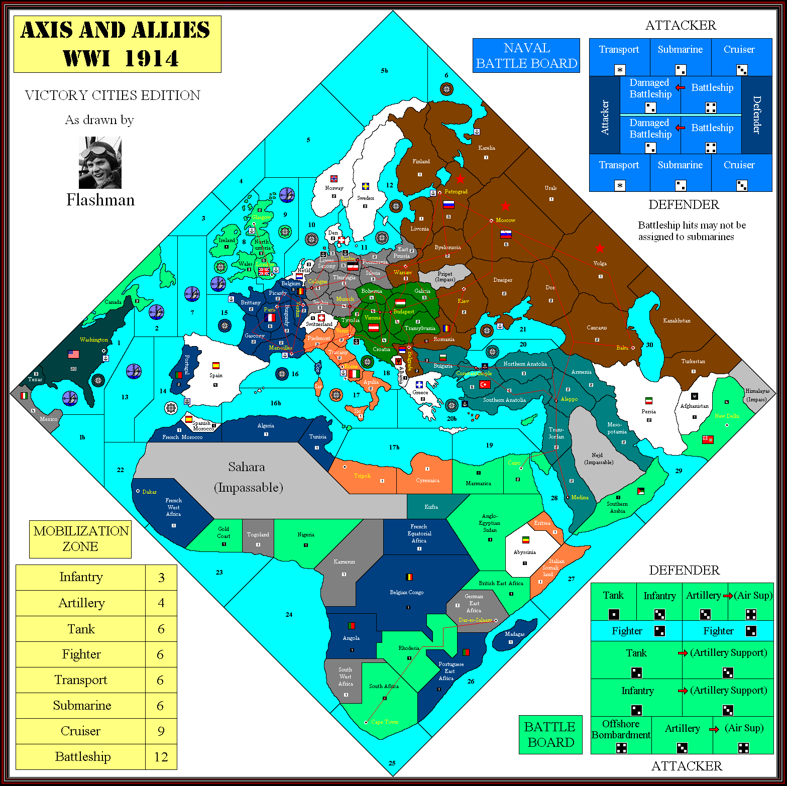
I don’t like spider webs on the map, poor aesthetic.
Move 2 spaces on land fixes the movement issue.
@Imperious:
The OOB setup/IPCs greatly favors the Allies!
So why not give the CPs some meat (like Poland with 4 or 5 IPCs) if it correspondends with history?
(needs some playtesting, sure)The tournament RULES address that issue.
The map file addresses obvious Historical points raised by others and makes corrections.
The space between Russian capital and Berlin do allow Germany to grab less IPC than before due to the new distribution, but also makes it harder to reinforce them due to the capital’s location. That means a tradeoff.
I don’t make a map to address balance, rules are used to correct that.
Why make a new map neglecting the historical economic strength of the regions (again)?
OOB is wrong enough!
@Imperious:
I don’t like spider webs on the map, poor aesthetic.
Move 2 spaces on land fixes the movement issue.
They’re to illustrate potential moves, I’m not suggesting they’re drawn on the map.
Though I like 2 space moves (it was I that first suggested it) there’s something appealing to me in limiting it to VC to VC moves. It simulates the feeling of having set strategic objectives, and after attaining one you have to take time bringing up reserves to reinforce before targeting the next, as well as repairing and laying down the transport network.
For example Germany cannot just dash stright into the heart of Russia; consider the importance of Warsaw - control it and you can send new units stright there from Berlin. Serbia/Belgrade suddenly become worth attacking on A1!.
Faster transport within industrial areas you control and then slower progress into contested and enemy tt seems more authentic to me.
Why make a new map neglecting the historical economic strength of the regions (again)?
OOB is wrong enough!
Because that is less important than making a more balanced game.
@Imperious:
Why make a new map neglecting the historical economic strength of the regions (again)?
OOB is wrong enough!Because that is less important than making a more balanced game.
Correct, but in my opinion it is possible to deliver to both camps!
Example: If Poland gets more IPCs it:
1. helps CP balancewise
2. correctly refelcts Poland as the No1 industrial region of Imperial Russia.
So, where is the problem?
Correct, but in my opinion it is possible to deliver to both camps!
Example: If Poland gets more IPCs it:
1. helps CP balancewise
2. correctly refelcts Poland as the No1 industrial region of Imperial Russia.
It has not been proven and I can’t make Poland worth more because you are Polish. It doesn’t work that way. I don’t even think it was worth the most. What is Polands GDP in 1914?
Sorry guys I was very busy with other stuff in the last days and couldnt spend much time on the great new map.
Changes in the Set Up for Russia, Germany, Austria, Italy, Ottoman Empire, BE, France:
Russia:
Lithuania: 6 Inf 2 Art
Tallinn: 3 Inf 1 Art
St. Petersburg 6 Inf 2 Art
Sevastopol 6 Inf 2 Art
Austria-Hungary:
Trieste 3 Inf 1 Art
Tyrol 3 Inf 1 Art
Italy:
Venice 11 Inf 3 Art
Piedmont 1 Inf 1 Art
Germany:
Ruhr 12 Inf 4 Art
Alsace 7 Inf 4 Art
Hannover 6 Inf 3 Art
Pommerania 6 Inf 2 Art
Prussia 2 Inf 2 Art
Ottoman Empire:
Meopotamia 2 Inf 1 Art
Armenia 1 Inf
Naval Set Up:
BE
Sea Zone 4: 1 Cruiser
Sea Zone 9: 3 Battleship, 3 Cruisers, 2 Transport
Sea Zone 14: 1 Cruiser
Sea Zone 19: 1 Cruiser
Sea Zone 29: 1 Battleship, 1 Cruiser, 2 Transport
GE
Sea Zone 10: 2 Battleship, 2 Cruisers, 1 Submarine
Sea Zone 11: 1 Cruiser 1 Transport
Sea Zone 24: 1 Cruiser
France
Sea Zone 15: 1 Cruiser, 1 Transport
Sea Zone 16: 1 Battleship, 1 Cruiser, 1 Transport
I will post reports and pictures in the next days!
Check out the new map file. I understand that you made that setup for the Phase 2 map. Can you have a look at phase 3 map and see if you like it?
Also, what do you think of making Poland worth 3? Which other place will be reduced -1
Poland should not have more IPCs than Ukraine which was (because of cereals) more important for the CPs.
(search for the “peace for bread”)
Don´t like neutral Albania because it includes also Montenegro which was at war with the CPs and was a tough enemy for AH… (maybe you could give Serbia a coastline and name it Serbia/Montenegro with 4 IPcs while Albania has 1 IPC left)
I understand the correct historical alignement of Bulgaria to Germany, but I dont like to see this Balkanarmy represented by German units… It would still be better to see them represented by AH or OE…
Angola should be changed from frenchblue to the colours of the BE.
What about Flashmans suggestions ?
(Dividing Seazone 17 - Mark could be the bottom of the printed Fighter,
Finlands unhistorical coastline and the dividing of Trans Jordan)
Why did you change US IPCs back to 20 when they enter war in R6?
I was thinking about maybe splitting up Budapest into Transylvania and Budapest…
All I can say is that I like Phase 2 map very much and enjoyed playing with it last weekend.
Why did you change US IPCs back to 20 when they enter war in R6?
Because they build while neutral and having 40 IPC for 6 turns becomes a ridiculous horde of pieces. All this balancing is lost if you trade two turns for a cash cow of double income.
The other things i will look into.
40 IPCs was because they DONT build until entering the war which would be more historical and would also represent the strongest economy in the world at that time. With OOB the United States were even weaker than Russia or France…
Compare the 2 scenarios, after R10 US would be more powerful than OOB so it gives the CPs a little more time but crushes them at the end of the game even harder and could finally tip the scales (also more historical):
R1 R2 R3 R4 R5 R6 R7 R8 R9 R10 R11 R12
20 40 60 80 100 120 140 160 180 200 220 240
R6 R7 R8 R9 R10 R11 R12
40 80 120 160 200 240 280
Italy should also not collect income during R1.
40 IPCs was because they DONT build until entering the war which would be more historical and would also represent the strongest economy in the world at that time. With OOB the United States were even weaker than Russia or France…
Oh this was never explained. I think all the ideas need to be written out so the module can gain favor. You already got the setup, but that USA rule is a huge difference. So if Germany goes USW, the US also goes to 40 ipc ( at war status) correct?
Why shouldn’t Italy collect income?
Also, Ottomans should be neutral on O1
You´re right I didn´t explained that very well (though I did mention it in a comment at boardgamegeek I think)
At the beginning of the game everyone (including USA and Italy) gets his starting income.
With USW (My Rule: GE sub attacking one of the USW zones with a 12-sided dice; result will be split up between BE and USA, if its odd BE will suffer more) Germany can at least hit the 40 US- IPCs twice before Wilson will enter the war earlier than R6… (historicaly Germany did USW in 1915 but ended it after american protests and then again declared it in 1917) Yes after declaring war USA will collect 40 IPCs every Round !
Italy was during 1914 neutral and was not in the mood to fight with/against anybody.
That did not change until 1915 (R2) (IT not collecting income during R 1, along with my Setup changes for Venice,Tyrol and Triest also prevents the unhistorical first strike of AH against Italy in R1)
Ottoman Empire entered the war on October 29 1914. That means Round 1 (Aug14-Dec14).
Bump to revive topic.
Is this project still in the works? What you guy’s have done with the map (saw parts on Game Geek) looked pretty cool (great work IL). Do you have the new set-up and any rule changes at this time. Did you break-up that huge sz 17 (was in discretion), and/or have straight rules in place for Denmark, Gib and Constantinople?
I made no changes and Kept OOB.
1914 isn’t too interesting for me once i got the product. Most of the sculpts are crap, especially Dreadnoughts and ocean liners.
People with no Head, hands or feet could sculpt a better piece.
Hey flash, someone should make a tripleA map of your version of 1914.
From now on can we split Spain in half.
Even though its hardly relevant, its weird seeing a territory touch FIVE sea zones.

