@black_elk said in Working on a New Map 40/41: Seeking Suggestions:
perhaps with some map making type tutorials in the same way that Pact of Steel 2 taught how to create an xml and such
:+1:
My definite approval for giving the normally worthless pacific islands a value of 1! :-D
I’m convinced that something like this is necessary, to avoid island skipping by both sides, and to activate the theater beyond the usual b line to the money islands.
Aside from aesthetic stuff, my only concern would be the smaller territory space (for unit housing) on the Russian capital. Though how that plays out this may depend on the capital capture dynamic, and what sort of rules changes are involved.
There is a game in tripleA that used a somewhat similar production spread at the center of the map called Big World 1942, it used a city circle concept. As I recall the value of Moscow was at 4 ipcs, and this made for some really tense tight rope walking at the center, that really forced you to plan several rounds in advance. I always felt 4 was a bit low, though on that map G had more production in its core, and cheap Revised style tanks, which made the center crush easier to pull off. This might not be as much of an issue using a map based on the 1942.2 ruleset and unit cost structure.
Nice stuff though. I always enjoy seeing people ideas about new production spreads. These draft maps above, are much more in line with my ideal production spread and views on how to promote overall replay and theater balance, than the OOB 1942.2 map or the 1940 maps.
Cool stuff dude
“Volgograd” was not so named until after the death of Stalin.
Really hate maps that remove Germany’s north sea coastline.
Also hate that “West Russia” tt sticking into Russia in 1942; if you look at the front it was nothing like that - should be a more or less straight line Leningrad-Moscow-Stalingrad.
The real value in Pacific islands was as air bases for the Allies to reach bombing range for Japanese home islands. This is only effective if US/UK units are not allowed on USSR tts.
Is poor shrivelled little Irish Free State worth nothing?
Good comments, everyone!
So, in the next draft, I will up Moscow’s production to $5, color the French African colonies khaki on the '42/'43 maps, and show a $2 production for Eire.
Black_Elk, I used to play a bit of Big World on TripleA – the circle city concept was the only part of it I liked! That’s definitely where I stole the idea from. :-)
Flashman, I’m interested in hearing more about Germany’s north sea coastline and about West Russia’s borders – why are they important to you? Does it impact the game strategy somehow? How would you prefer to draw them? I don’t really understand what you mean by a “straight line” from Leningrad to Moscow to Stalingrad. Do you mean all three of those cities should be an equal distance from Berlin? Or just that it’s important for them to line up on the same line of longitude?
As far as I know, “Volgograd” was the name of the administrative district around Stalingrad both before, during, and after Stalin’s reign. The city, of course, changed its name from time to time.
Eastern Front should look more like this:
http://ww2.odu.edu/~jkoch/hist396/downloads/495.Eastern Front Map 1942.jpg
Netherlands and Denmark do not have a common border - Lower Saxony is in between. If you don’t want a single sea zone between UK & Germany it’s better to change where the sea zone border is drawn so that the entire German coast effectively lies within the Baltic.
Do you have any setup for any scenarios?
Poland is too far East, and Romania should have a Black Sea coastline.
balts.PNG_thumb
balts.PNG_thumb
balts.PNG_thumb
balts.PNG_thumb
balts.PNG_thumb
balts.PNG_thumb
balts.PNG_thumb
balts.PNG_thumb
balts.PNG_thumb
balts.PNG_thumb
balts.PNG_thumb
balts.PNG_thumb
balts.PNG_thumb
balts.PNG_thumb
balts.PNG_thumb
balts.PNG_thumb
balts.PNG_thumb
balts.PNG_thumb
balts.PNG_thumb
balts.PNG_thumb
balts.PNG_thumb
balts.PNG_thumb
balts.PNG_thumb
balts.PNG_thumb
balts.PNG_thumb
balts.PNG_thumb
balts.PNG_thumb
balts.PNG_thumb
balts.PNG_thumb
balts.PNG_thumb
balts.PNG_thumb
balts.PNG_thumb
balts.PNG_thumb
balts.PNG_thumb
balts.PNG_thumb
balts.PNG_thumb
balts.PNG_thumb
balts.PNG_thumb
balts.PNG_thumb
balts.PNG_thumb
balts.PNG_thumb
balts.PNG_thumb
balts.PNG_thumb
balts.PNG_thumb
balts.PNG_thumb
balts.PNG_thumb
balts.PNG_thumb
balts.PNG_thumb
balts.PNG_thumb
balts.PNG_thumb
balts.PNG_thumb
balts.PNG_thumb
balts.PNG_thumb
balts.PNG_thumb
balts.PNG_thumb
balts.PNG_thumb
balts.PNG_thumb
balts.PNG_thumb
balts.PNG_thumb
balts.PNG_thumb
balts.PNG_thumb
balts.PNG_thumb
balts.PNG_thumb
balts.PNG_thumb
balts.PNG_thumb
balts.PNG_thumb
balts.PNG_thumb
balts.PNG_thumb
balts.PNG_thumb
balts.PNG_thumb
balts.PNG_thumb
balts.PNG_thumb
balts.PNG_thumb
balts.PNG_thumb
balts.PNG_thumb
balts.PNG_thumb
balts.PNG_thumb
balts.PNG_thumb
balts.PNG_thumb
balts.PNG_thumb
balts.PNG_thumb
balts.PNG_thumb
balts.PNG_thumb
balts.PNG_thumb
balts.PNG_thumb
balts.PNG_thumb
balts.PNG_thumb
balts.PNG_thumb
balts.PNG_thumb
balts.PNG_thumb
balts.PNG_thumb
balts.PNG_thumb
balts.PNG_thumb
balts.PNG_thumb
balts.PNG_thumb
balts.PNG_thumb
balts.PNG_thumb
balts.PNG_thumb
balts.PNG_thumb
balts.PNG_thumb
balts.PNG_thumb
balts.PNG_thumb
balts.PNG_thumb
balts.PNG_thumb
balts.PNG_thumb
balts.PNG_thumb
balts.PNG_thumb
balts.PNG_thumb
balts.PNG_thumb
balts.PNG_thumb
balts.PNG_thumb
balts.PNG_thumb
balts.PNG_thumb
balts.PNG_thumb
balts.PNG_thumb
balts.PNG_thumb
balts.PNG_thumb
balts.PNG_thumb
balts.PNG_thumb
balts.PNG_thumb
balts.PNG_thumb
balts.PNG_thumb
balts.PNG_thumb
balts.PNG_thumb
balts.PNG_thumb
balts.PNG_thumb
balts.PNG_thumb
balts.PNG_thumb
balts.PNG_thumb
balts.PNG_thumb
balts.PNG_thumb
balts.PNG_thumb
balts.PNG_thumb
balts.PNG_thumb
balts.PNG_thumb
balts.PNG_thumb
balts.PNG_thumb
balts.PNG_thumb
balts.PNG_thumb
balts.PNG_thumb
balts.PNG_thumb
balts.PNG_thumb
balts.PNG_thumb
balts.PNG_thumb
balts.PNG_thumb
balts.PNG_thumb
balts.PNG_thumb
balts.PNG_thumb
balts.PNG_thumb
balts.PNG_thumb
OK, here’s the second draft! Thanks again to everyone for all the helpful feedback.
Frederick II requested setup charts – is anyone else interested in seeing setup charts? If so, please vote up this comment or say so in a reply. If I get at least three people who want to see a setup chart, I’ll make one for 1939, and if I get at least five people, then I’ll make one for 1943, also.
Flashman, I just wanted to take a minute to acknowledge a couple of your suggestions that didn’t make it into this draft. You proposed a German port on the North Sea and a German enclave near Kaliningrad / Konigsburg. As a matter of history, you’re absolutely correct. The downside to adding in these tiny territories is that it further crowds a section of the map that is already very fiddly without doing much to enhance the available strategic options. In my opinion, the extra historical accuracy is not worth the price of having to crowd the soldiers in northern europe so closely together that they wind up knocking each other over. My philosophy for A&A in general, and this map in particular, is to try to maximize the strategic options while still respecting the fun-factor of seeing conflicts that at least remind us of conflicts from World War II. Some players prefer to get a simulation of history that’s as realistic as possible, and that’s fine, but that’s not what I’m trying to do here.
1939 map v2.png_thumb
1943 map v2.png_thumb
1939 map v2.png_thumb
1943 map v2.png_thumb
1939 map v2.png_thumb
1943 map v2.png_thumb
1939 map v2.png_thumb
1943 map v2.png_thumb
1939 map v2.png_thumb
1943 map v2.png_thumb
1939 map v2.png_thumb
1943 map v2.png_thumb
1939 map v2.png_thumb
1943 map v2.png_thumb
1939 map v2.png_thumb
1943 map v2.png_thumb
1939 map v2.png_thumb
1943 map v2.png_thumb
1939 map v2.png_thumb
1943 map v2.png_thumb
1939 map v2.png_thumb
1943 map v2.png_thumb
1939 map v2.png_thumb
1943 map v2.png_thumb
1939 map v2.png_thumb
1943 map v2.png_thumb
1939 map v2.png_thumb
1943 map v2.png_thumb
1939 map v2.png_thumb
1943 map v2.png_thumb
1939 map v2.png_thumb
1943 map v2.png_thumb
1939 map v2.png_thumb
1943 map v2.png_thumb
1939 map v2.png_thumb
1943 map v2.png_thumb
1939 map v2.png_thumb
1943 map v2.png_thumb
1939 map v2.png_thumb
1943 map v2.png_thumb
1939 map v2.png_thumb
1943 map v2.png_thumb
1939 map v2.png_thumb
1943 map v2.png_thumb
1939 map v2.png_thumb
1943 map v2.png_thumb
1939 map v2.png_thumb
1943 map v2.png_thumb
1939 map v2.png_thumb
1943 map v2.png_thumb
1939 map v2.png_thumb
1943 map v2.png_thumb
1939 map v2.png_thumb
1943 map v2.png_thumb
1939 map v2.png_thumb
1943 map v2.png_thumb
1939 map v2.png_thumb
1943 map v2.png_thumb
1939 map v2.png_thumb
1943 map v2.png_thumb
1939 map v2.png_thumb
1943 map v2.png_thumb
1939 map v2.png_thumb
1943 map v2.png_thumb
1939 map v2.png_thumb
1943 map v2.png_thumb
1939 map v2.png_thumb
1943 map v2.png_thumb
1939 map v2.png_thumb
1943 map v2.png_thumb
1939 map v2.png_thumb
1943 map v2.png_thumb
1939 map v2.png_thumb
1943 map v2.png_thumb
1939 map v2.png_thumb
1943 map v2.png_thumb
1939 map v2.png_thumb
1943 map v2.png_thumb
1939 map v2.png_thumb
1943 map v2.png_thumb
1939 map v2.png_thumb
1943 map v2.png_thumb
1939 map v2.png_thumb
1943 map v2.png_thumb
1939 map v2.png_thumb
1943 map v2.png_thumb
1939 map v2.png_thumb
1943 map v2.png_thumb
1939 map v2.png_thumb
1943 map v2.png_thumb
1939 map v2.png_thumb
1943 map v2.png_thumb
1939 map v2.png_thumb
1943 map v2.png_thumb
1939 map v2.png_thumb
1943 map v2.png_thumb
1939 map v2.png_thumb
1943 map v2.png_thumb
1939 map v2.png_thumb
1943 map v2.png_thumb
1939 map v2.png_thumb
1943 map v2.png_thumb
1939 map v2.png_thumb
1943 map v2.png_thumb
1939 map v2.png_thumb
1943 map v2.png_thumb
1939 map v2.png_thumb
1943 map v2.png_thumb
1939 map v2.png_thumb
1943 map v2.png_thumb
1939 map v2.png_thumb
1943 map v2.png_thumb
1939 map v2.png_thumb
1943 map v2.png_thumb
1939 map v2.png_thumb
1943 map v2.png_thumb
1939 map v2.png_thumb
1943 map v2.png_thumb
1939 map v2.png_thumb
1943 map v2.png_thumb
1939 map v2.png_thumb
1943 map v2.png_thumb
1939 map v2.png_thumb
1943 map v2.png_thumb
1939 map v2.png_thumb
1943 map v2.png_thumb
1939 map v2.png_thumb
1943 map v2.png_thumb
1939 map v2.png_thumb
1943 map v2.png_thumb
1939 map v2.png_thumb
1943 map v2.png_thumb
1939 map v2.png_thumb
1943 map v2.png_thumb
1939 map v2.png_thumb
1943 map v2.png_thumb
1939 map v2.png_thumb
1943 map v2.png_thumb
1939 map v2.png_thumb
1943 map v2.png_thumb
1939 map v2.png_thumb
1943 map v2.png_thumb
1939 map v2.png_thumb
1943 map v2.png_thumb
1939 map v2.png_thumb
1943 map v2.png_thumb
1939 map v2.png_thumb
1943 map v2.png_thumb
1939 map v2.png_thumb
1943 map v2.png_thumb
1939 map v2.png_thumb
1943 map v2.png_thumb
1939 map v2.png_thumb
1943 map v2.png_thumb
1939 map v2.png_thumb
1943 map v2.png_thumb
1939 map v2.png_thumb
1943 map v2.png_thumb
1939 map v2.png_thumb
1943 map v2.png_thumb
1939 map v2.png_thumb
1943 map v2.png_thumb
1939 map v2.png_thumb
1943 map v2.png_thumb
1939 map v2.png_thumb
1943 map v2.png_thumb
1939 map v2.png_thumb
1943 map v2.png_thumb
1939 map v2.png_thumb
1943 map v2.png_thumb
1939 map v2.png_thumb
1943 map v2.png_thumb
1939 map v2.png_thumb
1943 map v2.png_thumb
1939 map v2.png_thumb
1943 map v2.png_thumb
1939 map v2.png_thumb
1943 map v2.png_thumb
1939 map v2.png_thumb
1943 map v2.png_thumb
1939 map v2.png_thumb
1943 map v2.png_thumb
1939 map v2.png_thumb
1943 map v2.png_thumb
1939 map v2.png_thumb
1943 map v2.png_thumb
1939 map v2.png_thumb
1943 map v2.png_thumb
1939 map v2.png_thumb
1943 map v2.png_thumb
1939 map v2.png_thumb
1943 map v2.png_thumb
1939 map v2.png_thumb
1943 map v2.png_thumb
1939 map v2.png_thumb
1943 map v2.png_thumb
1939 map v2.png_thumb
1943 map v2.png_thumb
1939 map v2.png_thumb
1943 map v2.png_thumb
1939 map v2.png_thumb
1943 map v2.png_thumb
1939 map v2.png_thumb
1943 map v2.png_thumb
1939 map v2.png_thumb
1943 map v2.png_thumb
1939 map v2.png_thumb
1943 map v2.png_thumb
1939 map v2.png_thumb
1943 map v2.png_thumb
1939 map v2.png_thumb
1943 map v2.png_thumb
1939 map v2.png_thumb
1943 map v2.png_thumb
1939 map v2.png_thumb
1943 map v2.png_thumb
1939 map v2.png_thumb
1943 map v2.png_thumb
1939 map v2.png_thumb
1943 map v2.png_thumb
1939 map v2.png_thumb
1943 map v2.png_thumb
1939 map v2.png_thumb
1943 map v2.png_thumb
1939 map v2.png_thumb
1943 map v2.png_thumb
1939 map v2.png_thumb
1943 map v2.png_thumb
1939 map v2.png_thumb
1943 map v2.png_thumb
1939 map v2.png_thumb
1943 map v2.png_thumb
1939 map v2.png_thumb
1943 map v2.png_thumb
1939 map v2.png_thumb
1943 map v2.png_thumb
1939 map v2.png_thumb
1943 map v2.png_thumb
1939 map v2.png_thumb
1943 map v2.png_thumb
1939 map v2.png_thumb
1943 map v2.png_thumb
1939 map v2.png_thumb
1943 map v2.png_thumb
Hi Argothair,
nice job. But you should divide the East Indies and Borneo into two Islands each – Java & Sumatra and Borneo & Celebes – and maybe transfer the income from the smaller pacific islands to them.
In my opinion, the extra historical accuracy is not worth the price of having to crowd the soldiers in northern europe so closely together that they wind up knocking each other over. My philosophy for A&A in general, and this map in particular, is to try to maximize the strategic options while still respecting the fun-factor of seeing conflicts that at least remind us of conflicts from World War II. Some players prefer to get a simulation of history that’s as realistic as possible, and that’s fine, but that’s not what I’m trying to do here.
Since historical accuracy isn’t a map priority, is this also the case for geographic accuracy? If geography doesn’t matter, there’s presumably no need for people to provide feedback on geographic issues; however if it does matter, there are potentially some things that need revision. They don’t necessarily involve border changes (since you’ve said you don’t want to change your borders); some simply involve labeling changes. For example: the territory labeled “Persia” encompasses the territory of two separate countries and it would be more accurate to call it “Iraq / Persia”. Another example: “Pakistan” didn’t exist until 1947, so a different name (like “North-West India”) would be more accurate.
I just realized that you don’t have any seazones with any numbers. So are you planing something about that?
Could I vote for the setup? Or since I brought that up you want other people to vote.
CWO Marc, if it’s important to you, then I’ll change the names to Iraq / Persia and North-West India. Geography is part of how we know what we’re looking at, which adds to the fun factor. I’m willing to change borders, too, where that makes sense – I just don’t want to add lots of tiny territories where soldiers won’t fit. I did in fact change several borders in response to Flashman’s comments.
Frederick, you can vote, that’s fine. I’ll work on numbers for the sea zones.
Hessian, I could split up indonesia into four territories (five if you count Malay), but I don’t think it’s appropriate given the relatively low unit count I’m going to be aiming for on the setup – if I split up the islands, then Japan needs four transports to take Java, Celebes, Borneo and Sumatra in one turn, but with four loaded transports you could go crazy on the mainland, for example, land in Burma and take India on turn 2. As a compromise, I might just split “East Indies” into Java and Sumatra – there’s plenty of room in the sea zone, and it could be kind of cool to have two island territories in the same sea zone. That’s something other maps haven’t really done.
I’m not going to transfer the income from the small Pacific islands over to Indonesia, because I want to reward players for island-hopping across the Pacific.
CWO Marc, if it’s important to you, then I’ll change the names to Iraq / Persia and North-West India.
I was actually just trying to get a sense of whether those kinds of things are important to you. I wasn’t lobbying for you to change your map based on what I consider to be important; I simply wanted to get a better idea of what your own priorities were with regard to geographic accuracy.
I simply wanted to get a better idea of what your own priorities were with regard to geographic accuracy.
Fair enough; sorry if I laid a guilt trip on you.
The answer is that no, I don’t care much. I know where Iraq is and when Pakistan was founded, but I don’t feel any special need to show that on the map. The map is also missing Syria, Palestine, Czechoslovakia, Albania, Ceylon, Taiwan, Sakhalin, the Aleutian islands, Guatemala, Honduras, El Salvador, Uruguay, Paraguay, and Guyana, but I’m cool with that. I’m not sure the name “Kenya” was used until shortly after World War II, but, again, that’s OK with me. I’d rather use a name that contemporary people are familiar with and can relate to than a name that’s more historically accurate but more obscure, like Tanganyika.
Still don’t like “Greater Denmark”. Germany did have a north sea coast, and the Allies seriously considered invading Germany by this direct route.
Tunisia was a French colony; this would be more accurately called Tripolitania.
This arrangement of the Suez canal is another artefact from the original game; the canal runs through Egypt, not between Egypt and Jordan. This was finally corrected in A&A 1914.
The TT called Kenya here covers what was at the time referred to as British East Africa.
What you’ve called Rhodesia more closely corresponds to Tanganyika.
Karelia is the isthmus in the south of your Murmansk tt.
Hong Kong was not important militarily, I’d make this then Chinese province of Canton.
Gibraltar is another artefact, I prefer that UK can use the port there if Spain is neutral, but it’s not a land tt.
I’d suggest adding the Pripet marsh (impassable to armour/mech/art) in Russia.
I prefer a different arrangement of India, with the capital (New Delhi) as VC thus protected from invasion via Burma.
Viet Nam would be more authentically called “Indochina”.
Germany never reached the oilfields of Baku, so I’d separate Caucasus from a northern “Don” region.
https://en.wikipedia.org/wiki/Case_Blue#/media/File:Eastern_Front_1942-05_to_1942-11.png
What is your evidence that the term Volgograd was used before 1961?
https://en.wikipedia.org/wiki/Volgograd_Oblast
India mod.PNG_thumb
India mod.PNG_thumb
DonTT.PNG_thumb
DonTT.PNG_thumb
DonTT.PNG_thumb
DonTT.PNG_thumb
DonTT.PNG_thumb
India mod1.PNG_thumb
DonTT.PNG_thumb
India mod1.PNG_thumb
DonTT.PNG_thumb
India mod1.PNG_thumb
DonTT.PNG_thumb
India mod1.PNG_thumb
DonTT.PNG_thumb
India mod1.PNG_thumb
DonTT.PNG_thumb
India mod1.PNG_thumb
DonTT.PNG_thumb
India mod1.PNG_thumb
DonTT.PNG_thumb
India mod1.PNG_thumb
DonTT.PNG_thumb
India mod1.PNG_thumb
DonTT.PNG_thumb
India mod1.PNG_thumb
DonTT.PNG_thumb
India mod1.PNG_thumb
DonTT.PNG_thumb
India mod1.PNG_thumb
DonTT.PNG_thumb
India mod1.PNG_thumb
DonTT.PNG_thumb
India mod1.PNG_thumb
DonTT.PNG_thumb
India mod1.PNG_thumb
DonTT.PNG_thumb
India mod1.PNG_thumb
DonTT.PNG_thumb
India mod1.PNG_thumb
DonTT.PNG_thumb
India mod1.PNG_thumb
DonTT.PNG_thumb
India mod1.PNG_thumb
DonTT.PNG_thumb
India mod1.PNG_thumb
DonTT.PNG_thumb
India mod1.PNG_thumb
DonTT.PNG_thumb
India mod1.PNG_thumb
DonTT.PNG_thumb
India mod1.PNG_thumb
DonTT.PNG_thumb
India mod1.PNG_thumb
DonTT.PNG_thumb
India mod1.PNG_thumb
DonTT.PNG_thumb
India mod1.PNG_thumb
DonTT.PNG_thumb
India mod1.PNG_thumb
DonTT.PNG_thumb
India mod1.PNG_thumb
DonTT.PNG_thumb
India mod1.PNG_thumb
DonTT.PNG_thumb
India mod1.PNG_thumb
DonTT.PNG_thumb
India mod1.PNG_thumb
DonTT.PNG_thumb
India mod1.PNG_thumb
DonTT.PNG_thumb
India mod1.PNG_thumb
DonTT.PNG_thumb
India mod1.PNG_thumb
DonTT.PNG_thumb
India mod1.PNG_thumb
DonTT.PNG_thumb
India mod1.PNG_thumb
DonTT.PNG_thumb
India mod1.PNG_thumb
DonTT.PNG_thumb
India mod1.PNG_thumb
DonTT.PNG_thumb
India mod1.PNG_thumb
DonTT.PNG_thumb
India mod1.PNG_thumb
DonTT.PNG_thumb
India mod1.PNG_thumb
DonTT.PNG_thumb
India mod1.PNG_thumb
DonTT.PNG_thumb
India mod1.PNG_thumb
DonTT.PNG_thumb
India mod1.PNG_thumb
DonTT.PNG_thumb
India mod1.PNG_thumb
DonTT.PNG_thumb
India mod1.PNG_thumb
DonTT.PNG_thumb
India mod1.PNG_thumb
DonTT.PNG_thumb
India mod1.PNG_thumb
DonTT.PNG_thumb
India mod1.PNG_thumb
DonTT.PNG_thumb
India mod1.PNG_thumb
DonTT.PNG_thumb
India mod1.PNG_thumb
DonTT.PNG_thumb
India mod1.PNG_thumb
DonTT.PNG_thumb
India mod1.PNG_thumb
DonTT.PNG_thumb
India mod1.PNG_thumb
DonTT.PNG_thumb
India mod1.PNG_thumb
DonTT.PNG_thumb
India mod1.PNG_thumb
DonTT.PNG_thumb
India mod1.PNG_thumb
DonTT.PNG_thumb
India mod1.PNG_thumb
DonTT.PNG_thumb
India mod1.PNG_thumb
DonTT.PNG_thumb
India mod1.PNG_thumb
DonTT.PNG_thumb
India mod1.PNG_thumb
DonTT.PNG_thumb
India mod1.PNG_thumb
DonTT.PNG_thumb
India mod1.PNG_thumb
DonTT.PNG_thumb
India mod1.PNG_thumb
DonTT.PNG_thumb
India mod1.PNG_thumb
DonTT.PNG_thumb
India mod1.PNG_thumb
DonTT.PNG_thumb
India mod1.PNG_thumb
DonTT.PNG_thumb
India mod1.PNG_thumb
DonTT.PNG_thumb
India mod1.PNG_thumb
Frederick, you can vote, that’s fine. I’ll work on numbers for the sea zones.
Ok than I vote +1 up.
From an overall map design standpoint, the important thing is that you find the basic territory connections that you like first, because there are definite limits to what you can do in terms of “geographical accuracy” when using such an abstracted baseline map projection.
Just to be clear, I didn’t draw that Revised/1942.2 baseline for tripleA. In fact it was my frustration with tripleA’s Revised map, that made me start wanting to draw a better A&A map in the first place.
I rather liked Logan’s Classic map for tripleA, but the Revised map always got under my skin hehe. I’m not sure who put it together, it may have been Logan, but I couldn’t say for sure. Alas, Revised was the most popular TripleA game at the time, and when Spring 1942, and 1942 second edition came out, the same basic baseline was used, I guess for familiarity. But I was never a fan of that particular design.
It used way too much “Blob” and “jiggery borders” for my taste. The sort of thing that a history teacher might draw on a chalkboard from memory… good enough to get the point across, but totally abstracted and wonky when put up against an image of the real world.
On the other hand, mercator is equally ill-suited to the task, since in Mercator all the important areas for A&A gameplay are way too small, and all the irrelevant areas are way too large!
I much preferred the AA50 design in tripleA (since I drew it, I’m obviously biased haha) which was intended as a compromise. I actually posted a lot of different ideas on the Larry boards, for possible projections that would be more accurate yet still accommodate the gameplay. Global was an improvement, but it still utilizes the “blob effect” much more than I’d like.
All OOB Axis and Allies maps do 2 things which make Geographical accuracy difficult:
First, they englarge Europe and the Asia/Pacific region.
And second, they shrink everywhere else on the globe!
This creates what I’ve called the “center squeeze” or the “center squish.” :-D
If you imagine stretching and bending the image of the globe so that Europe and the Asia/Pacific region are basically twice their normal size, while simultaneously contorting the Americas and Africa so they are reduced to half their normal size, you can start to see why the “blob effect” constantly reappears in A&A. Because if you don’t blob things out, the world itself and all the national borders start to become totally unrecognizable. Shaky border lines are necessary, because none of the rivers or mountains or cities or other guideposts you might use, end up where they should be, when you blow Europe out to the necessary size to house sculpts. It’s a bind for sure.
A&A maps tend to exploit the fact that most people have no idea what some obscure central Russian territory actually looks like, or where it’s supposed to be in relation to all the other obscure central Russian territories. So you can move Moscow like a couple thousand miles east of where it is in reality, and nobody bats an eye. Because in Classic and Revised, they’re all just big blobs anyway. Once you start trying to divide things up into more nuanced regions though, things get tricky.
Basically, the whole center area of the game map is a wonky hodgepodge of distortions. The Middle East, India, China, and pretty much all of Russia, don’t really align the way they would if the world was presented to scale. Add to that the need for a huge Mediterranean sea (to fit all those ship sculpts) and this is basically what we’re up against.
The closest I ever got to something that seemed relatively accurate, yet still scaled so that it might be playable for A&A was this map below. But there are way more territories than you’d need. The reason I drew it this way was so borders could be erased and collapsed to form larger territories, rather than blobbed in at random. So here at least, if you want to find a place like Saxony, or if you want to know where the Elbe is or the Don, or where that would be in relation to the Danube or the Volga, you can kind of follow an outline that roughly matches the political map of a Mercator projection.
Clearly there is still a lot of distortion, but at least you can kind of work through it when you look at the territory tiles relative to each other.
My advice would be to find territory connections that you think would be enjoyable for the gameplay (using whatever map you like, the 1942.2 one above say). Then, once you have the connections you like, you can port those into a map projection more like this one, collapsing and erasing lines where necessary so it matches your gameplay vision, and then give the territories whatever names would make sense for the regions they end up encompassing. ;)
Basically to take the guess work out of it, since the territory shapes here should fit the puzzle of the actual globe (unlike the territory tiles on TripleA’s Revised map or the 1942.2 map which grew out of it, which are both pretty random). Erase whatever is unnecessary (islands, regions, whatever, until it fits the scope you’re after.) Expand the Oceans if desired, since its all just the same color blue and mostly empty space (aside from a few islands that are fairly easy to shimmy around, or eliminate or redraw), you can pretty much make the Oceans as wide as you like.
Then you just double or triple the scale of the baseline map, so that it’s large enough for your game, and give the territories a border graphic, a nice clean border. One that is larger than the 1 pixel line here, so it looks decent when you print it out. Add in some skins or relief graphics, if desired, and you’re basically good to go.
:-D
World_Map_Jason_Clark.png_thumb
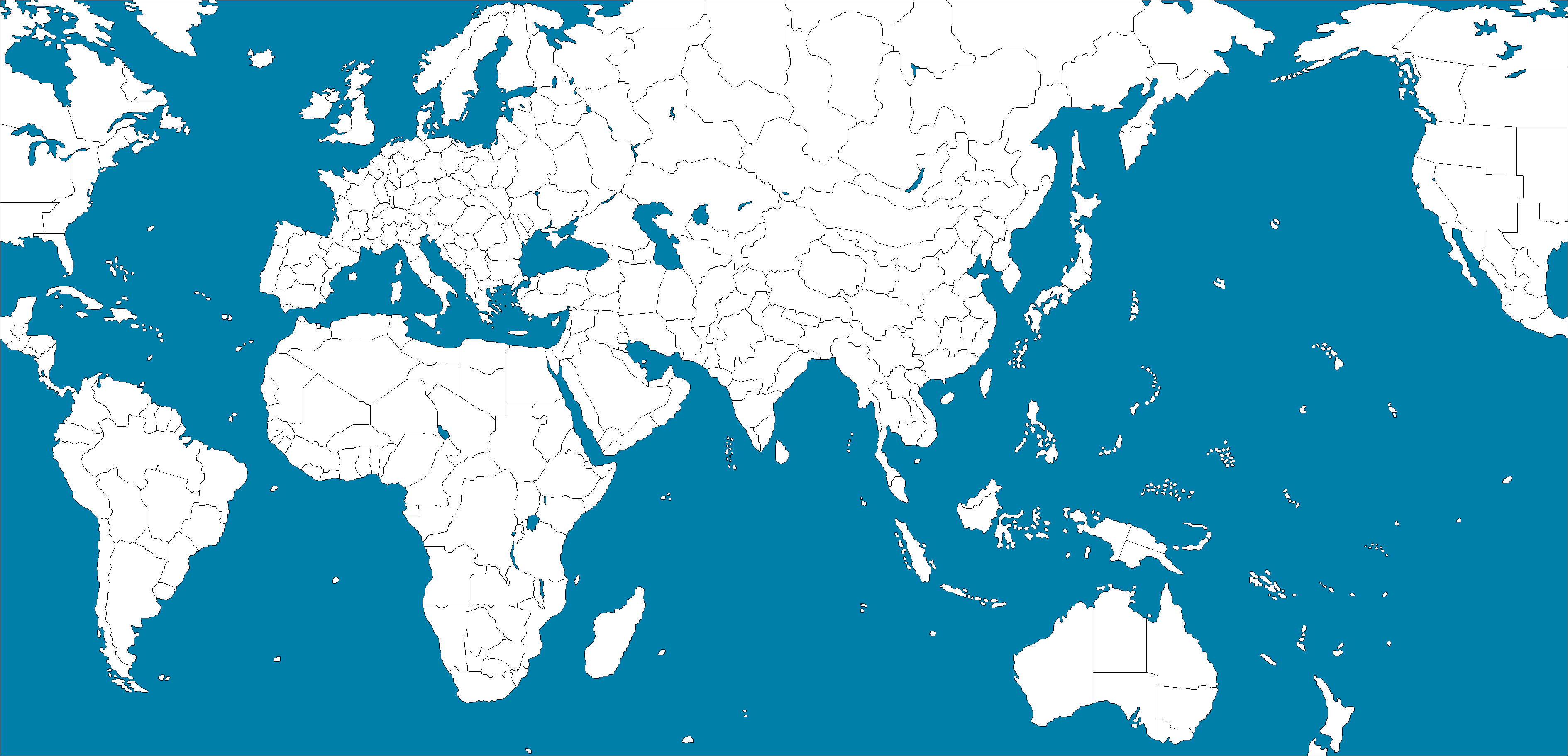
It’s true that A&A maps (and A&A-type maps from other games) always include distortions, with diffent areas being shrunk or expanded or re-proportioned. Different maps, however, do it to varying degrees. In the Global 1940 map, for instance, Africa is about twice as wide as it’s tall – but in this map…
http://www.boardgamegeek.com/image/672203/wwii-struggle-europe-and-asia?size=large
…it’s three or perhaps even four times wider than it’s tall, which to me at least makes the continent unrecognizable. Generally speaking I quite like the Global 1940 map, both because of its semi-topographical look and because the distortions it contains are (speaking very generally, and acknowledging that there are exceptions) distortions of size rather than distortions of shape. South America, for example, is much too small relative to Africa, but its overall shape is pretty accurate.
From a game-map perspective, two big problems with the real world are that it’s spherical (meaning that any flat map will include distortions due to projection requirements) and that it contains both an awful lot of “wasted” space and an awful lot of “crowded” space. The Pacific Ocean is an obvious example of wasted space: it’s mostly empty, yet it covers about one-third of the world’s surface. A similar but less obvious problem is that most of the world’s land masses are located in the northern hemisphere, which contains all of North America and Europe, virtually all of Asia (the world’s largest continent, with 30% of Earth’s land area), and more than half of Africa. The only appreciable land masses below the Equator are the majority of South America, the lower section of Africa, and all of Australia, New Zealand and Antarctica; the rest of the southern hemisphere is mostly water.
Some of the world’s land areas have the opposite problem: they’re too crowded. The land area running west-to-east from France to the Volga and north-to-south from the Baltic coast to the Mediterranean coast is tiny on a proper world map, or on a globe, but most of the fighting in WWII (if you go by troop numbers and by military and civilian casualties) took place there. Since cramming that much action into a space that small is clearly impractical for game-mapping purposes, the tempting solution is to shrink the “wasted” mostly-empty parts of the world and to use the saved space to expand the “crowded” parts of the world where you need to deploy lots of troops and equipment. I think it’s a valid approach as long as one doesn’t go overboard and take the distortions too far (especially the distortions of shape, which I think are more problematic than distortions of size).
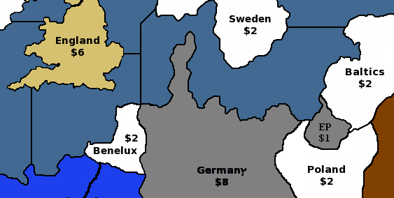
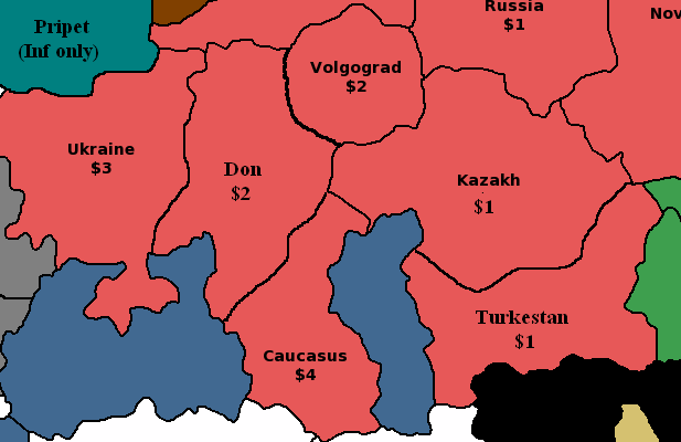
One side-effect, however, is what I’d call “cartographic determinism” – choosing what areas to expand (or even depict outright) and which ones to shrink (or even eliminate altogether) based on retroactive knowledge of where the major actions of WWII were actually fought (as opposed to where they might have been fought). For example, the Pacific 1940 map doesn’t mention Yap (which has a land area of 100 square kilometers) but it does mention Iwo Jima (which has a land area of just 21 square kilometers) because the latter was the site of a major amphibious campaign while the former was not. The Europe 1940 map allocates lots of space to northern Africa because of the Desert Campaign that was fought there, and little room to southern Africa because no land battles were fought there. Likewise, the map divides the country of Libya into two map territories: “Libya” to the west and “Tobruk” to the east. This east-west division has some geographic validity, since Libya did used to have three administrative divisions (Tripolitania in the northwest, Fezzan in the southwest, and Cyrenaica in the east), but the labeling reflects the events of WWII: Cyrenaica is called “Tobruk” because Tobruk – which is actually just a port city – was the site of major battles. And so forth. These are valid design decisions, but in a sense theymight subconsciously “channel” players into replicating the course of WWII as it was actually fought rather than leaving them more open to alternate courses of action.
I dislike the use of titles such as Tobruk rather than Cyrenaica; be consistant with regional names. Only capitals and/or Victory cities should be named for a town.
The 1914 map is a real hotchpotch of city and regional names, mainly because they just copied the layout of Diplomacy rather than designing the map from scratch.
Very interesting discussion on this thread – nice to have so many serious historians and cartographers!
Black_Elk, do you think my map would be significantly more appealing if I used the base tiles you most recently provided? I agree that it’s more geographically accurate, but I worry that players who are primarily familiar with A&A (and much less so with actual politics) would have difficulty recognizing some of the regions. I also am not confident of my ability to draw sea zones intelligently across the whole map – I’ve tried that before at home, and failed, even by my own standards.
CWO_Marc, what are some key changes you would make to help push back against cartographic determinism? I’m very interested in giving players as many plausible options as possible to take the war in different directions, rather than just mechanically reproducing minor variations on the historical conflicts. What territories need to be expanded (or collapsed) in order to make that happen?
Flashman, I like your labelling suggestions for Tripolitania and Indochina, and will switch them on the next draft. Do you know of another name for the area to the east of Leningrad that would be both recognizable and more accurate than “Karelia”? I’m also cautiously interested in your refactoring of India – my concern is that by splitting it up into 3 territories, you would deprive the British of a meaningful base / factory / center of operations in central Asia. We could increase New Delhi’s production to $2, but even then, the rich territory no longer borders the Indian Ocean, which stops the British from laying down ships in India – not fun for strategic game play. As a final thought, have you considered designing your own map? You always seem to have crisp illustrations ready to support your ideas – I bet if you designed a map, people would have a lot of interest in it.
CWO_Marc, what are some key changes you would make to help push back against cartographic determinism? I’m very interested in giving players as many plausible options as possible to take the war in different directions, rather than just mechanically reproducing minor variations on the historical conflicts. What territories need to be expanded (or collapsed) in order to make that happen?
That’s a hard question to answer because it’s not only an issue of territory sizes on the map; it also ties into other aspects of the game, such as the IPC value of territories, the political rules which govern who can go to war against whom under what circumstances, and the even larger question of victory conditions. All of these factors tend to channel the actions of the players. To mention just one example: the rules governing strict neutrals in the A&A 1940 rules are evidently meant to pressure players into staying away from the countries that remained neutral in WWII without putting an outright prohibition on invading them. The result is that players are essentially told, “yes, you can invade a strict neutral…but you’ll have to pay a stiff price for doing so,” which is a de facto restriction of their freedom of action even though it’s not a de jure one.
One way to approach this issue is from the opposite direction: by asking “Why would a player want to attack Territory X as opposed to Territory Y?”, regardless of whether one or the other was actually the site of a major historical WWII campaign. In purely abstract terms, it would be because the map and the rules and the disposition of the opposing forces on the board lead the player to conclude that it would be advantageous for him to do so – meaning that it would help advance him towards his goal of fulfilling the game’s victory conditions (whatever those happen to be), at an acceptable cost to him in casualties. So in a sense it’s a circular argument: if the goal of a player is to achieve certain victory conditions on a certain map, he will tend to do the things which the rules and the map encourage him to do. Freedom of action is, after all, a means to an end, not an end in itself; players (if they care about winning) don’t invade a particular country just for the fun of it, without giving any consideration to whether it has any value or not. To pick a deliberately extreme example: under the rules, the Soviet Union could put together a naval task force and try to launch an amphibious invasion of Peru; such a campaign would be perfectly legal, but it would be a colossal waste of time and resources, and the USSR would gain no benefits from it even if it succeeded.
In a sense, “cartographic determinism” isn’t pointless and isn’t really a bad thing because A&A does have a historical context which is an important part of the game’s appeal: the Second World War. (If A&A was set on a fictitious planet with a fictitious history, I’d personally have no interest in it no matter what the map looked like.) The A&A map and the rules should not be a straightjacket which only allow the war to be fought one way (otherwise there would be no point in playing because the game would always turn out the same), but by the same token the map and the rules should not be so open-ended that the game ends up having little or no resemblance to WWII. Most A&A players have at least a basic familiarity with the historical of WWII, and quite a few of them are outright history buffs, so it’s impossible for them to look at the A&A map without being influenced by their knowledge of what transpired at such-and-such a location. For example, the map territories of Egypt and Volgograd both have an IPC value of 2, and both contain an Allied victory city, so technically they’re equivalent…but the phrase “Cairo in WWII” does not (and should not) carry at all the same emotional weight as the phrase “Stalingrad in WWII.” So in my opinion, the right balance to try to achieve with alternate maps and alternate rules is to allow players to have fun with history while still staying recognizably within history.