


China Factions:
Mao’s Red Guard Take clearly different soldiers from another Axis and Allies game you own. 1 troop may spawn in either Ninxia or Chingai per round.
Chaing’s Nationalists: 1 troop spawn per Chinese coastal territory controlled. Take clearly different soldiers from another Axis and Allies game.
*The rules for Anniversary edition still apply (half of territories rounded down) representing unaligned Chinese units. These may attack with either the Red Guard or Nationalist but not with both. If a Communist force loses to Japanese and retreats, it must attack a Nationalist army if there is one adjacent. This represents the infighting which crippled Chinese forces and suspicion the two factions had against each other during the conflict.
Zhang Xueliang: son of a powerful Manchu warlord Zhang Zuolin who wished for the restoration of Manchu dominance of China. Northeast Chinese forces pledged loyalty to this Independent opiate infused warrior. Who will he align with?
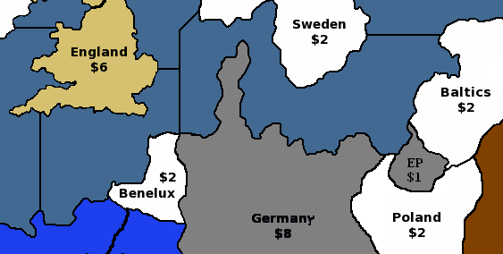
Discuss: If the majority of players decide to engage Zhang in the game, he overcomes his opiate addiction and womanizing ways. His loyalty to either Japan, Chinese Nationalists or Chinese Communists will be determined by the dice. Place an industrial center on Manchuria if not one already, or fully repair one. The IPCs for this region are now worth 4.
1 Zhang politically embraces communism and joins Mao’s forces. Place a tank, and three soldiers on the area.
2-3 “Communism was a cancer while the Japanese represented a superficial wound!” Zhang screams while surging onto the board with five soldiers allied to the Nationalists.
4-5 Zhang allies with the Japanese to restore the Qing Dynasty. Two Japanese soldiers and two artillery pieces placed. An attack on Soviet forces must occur within two rounds or Zhang will ally as a neutral Chinese force.
6 Zhang dies from an overdose
My Manchu grandfather was a destroyer captain for the Chinese Nationalists and passed down stories from this time. Manchuko’s politics were more independent than many realize. Historically Zhang sided with the Nationalists to help key victories and recognized as a hero by all Chinese. The scale of this struggle was as large as any European front, therefore, more infantry should be represented!
Have fun :)

