


When is the new english version coming out.
New version of my WWII A&A Style Game
-
Dear Ladies and Gentlemen;
After 20 years, and many years of game play… I have re-created my game WWII-The Complete Game. Thanks to the advancement of 3-d printing technology, I Will be putting out my new maps and rules for free again… I Will provide pics here…
The 6’ X 10’ vinyl map board.

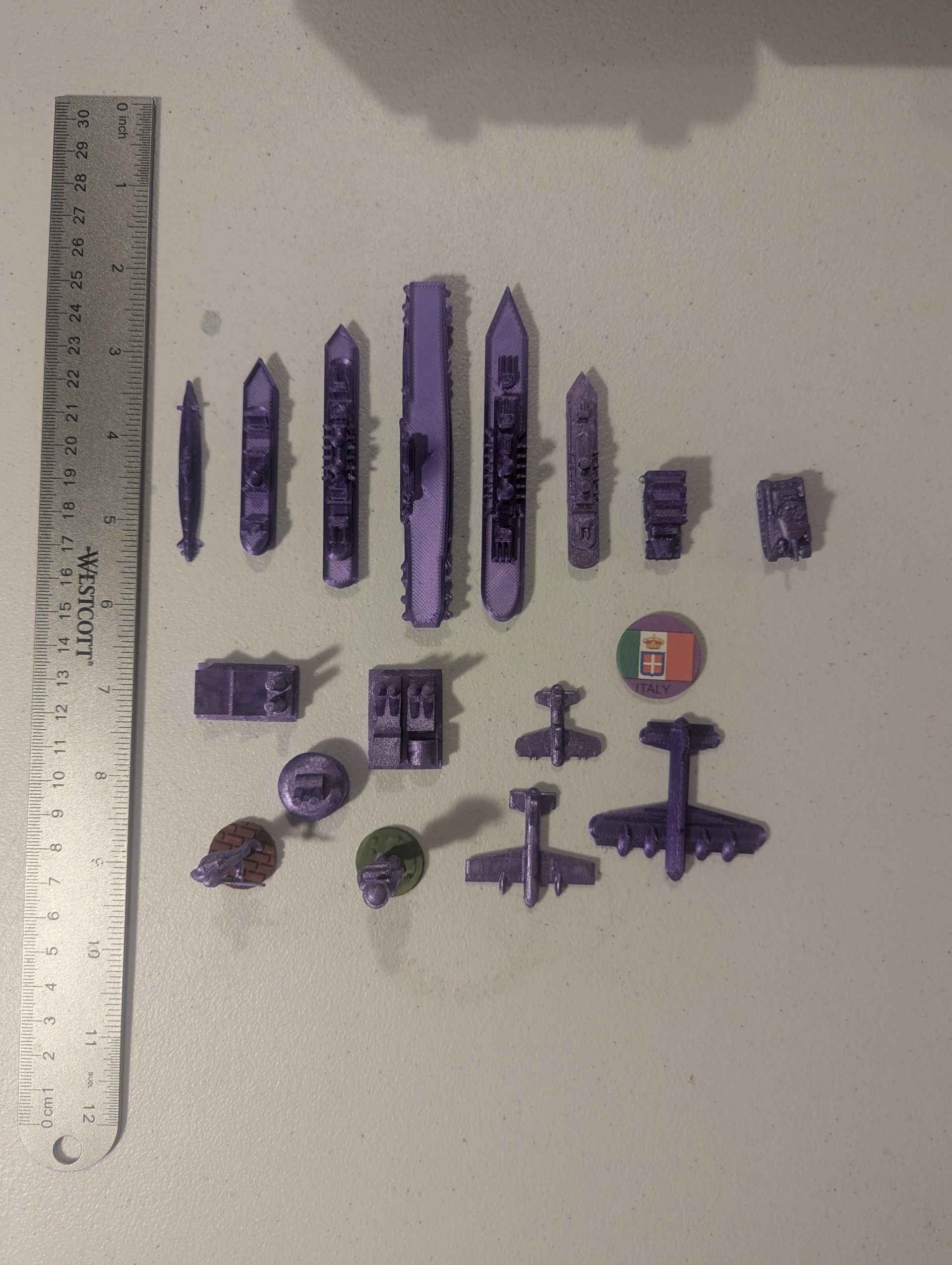
My Set of 3-d pieces…

Example of piece sizes.
Contact me for details to get free copy of map and rule .pdf files…
Charles Fontaine
-
@Charles-Fontaine If they’re free, can’t you send the map and rules here? I’m pretty sure you can send through a platform like Mediafire.
Besides that, it looks pretty solid! Looks interesting, especially due to the game’s scale. Although, I must ask: Why are Egypt, South Africa, and Tunisia neutral?
Good job on bringing back your old game!
-
This post is deleted! -
-
@CentralCommando I uploaded the rulebook… The pdf for the map is too big to upload here… 8 gb limit…
-
@CentralCommando All 3 of those according to my research were independent on Aug 31, 1939 which is the day the map is based on… The flags on the map are the flags they were flying on that date according to Wikipedia… If you have other research… I’d love to see it…
Email me at cefjr1961@gmail.com and Ill send you the pdf for the map… and the .STL files to make the 3-d pieces
Charles Fontaine
PS Ill be bringing this game to Game convention in St. Louis MO in Mis May, 2025
-
@Charles-Fontaine Egypt and Union of South Africa were British Dominions, Tunisia was a French protectorate.
https://en.wikipedia.org/wiki/History_of_Egypt_under_the_British
https://en.wikipedia.org/wiki/French_protectorate_of_Tunisia
https://en.wikipedia.org/wiki/Union_of_South_AfricaDang, the map is larger than 8GB and a 91-page rulebook? Holy smokes that’s massive! Thanks for the rulebook.
-
@CentralCommando According to my research… Tunisia became French Protectorate first week of Sept 1939 after the invasion of Poland and the Start of WWII… Egypt… after the treaty in 1936 only allowed British Soldiers in the Suez canal zone - which is a separate area on the Map and is shown under British control. As for South Africa, the Statute of Westminster passed by the British Parliament in December 1931, which repealed the Colonial Laws Validity Act and implemented the Balfour Declaration 1926, had a profound impact on the constitutional structure and status of the Union. The Union of south Africa flew the same flag from 1928 to 1994… 3 stripes with 3 small flags in the center. The map file because its a PDF of the full size CorelDRAW file… It is 15.9 MB… which is 7,9 MB too large for here… I misspoke before when I said 8 gb… its 8 mb… I hope you understand where I came from for the map… and in vinyl… it costs $220 to print another… I spent 4 months researching every single country to try to find the size - shapes - borders - control - and military contingent for each zone…
Charles Fontaine
-
@Charles-Fontaine I can’t find anything about the protectorate being formed in 1939, only 1881. However, I guess you were right about Egypt. I still think South Africa should be labeled as British though…
Also, you could use MediaFire for the map, I’m pretty sure they allow up to 2GB for free.
-
Sendspace works as well. I don’t think china allows media fire. For our international gamer friends :)
-
I will be demonstrating my new game at GEEKWAY to the West in St. Louis in May 2025… There will be 2 games on Friday and 2 on Saturday. The WWII setup of the game will be played each day from 0900 to 1430 each day… while the empire build-up no teams version will be played from 1630 to 2330 each day… Please see the web site for sign up and to get a badge to come to the convention…
Hope to see you there… Charles Fontaine
Suggested Topics

