


@private-panic Thanks very much, this seems to be what I am looking for.
Axis and Allies Complete
-
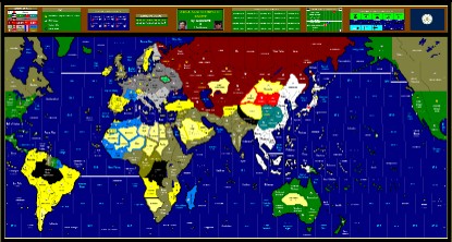
It was possible to cross the sahara from south to north. A small force of Free French from Equatorial Africa drove north through the desert to attack Axis outposts in Libya.
Can’t see this being done across the Himalayas, but just possibly the Amazon and Congo.
There are plenty of desert territories in the Sahara, but I’ve yet to decide just how they work. Perhaps a unit limit? This is complicated by making Libya and West Egypt desert, which is true enough for the terrain, but of course the forces in this campaign were supplied by sea.
Also considering Sinkiang, Kansu and NW Australia as deserts; the final decision on these depends on exactly what desert rules I adopt.
-
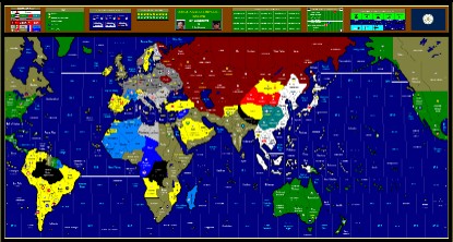
Update with improved Africa:
-
Yeah its hard to decouple rules and map.
But must try to decouple or things go around the circle.By the way, I find your continent lines fairly accurate.
(Was checking it against the 8MB earth lights map.)And are you using vector drawing?
-
To be honest, I made the mistake of starting with a scan of World at War. That put me wrong in so many ways the map has had a painful evolution. Several times I’ve had to cut out whole sections and relocate them, and add strips of map in three places to get the oceans an accceptable width. Most of the coastlines have been redrawn several times.
Tip: get the outline right before you do anything else!
What are vectors? I just use paint.
[attachment deleted by admin]
-
Paint works with pixels. Vector works with objects.
So with vector you can have shift things around very easily. Continents, names, and icons are all separate.
Also, vector is scalable. No pixelation when enlarged.
By the way, use gif instead of jpg for textureless maps (and cartoons). Its actually smaller yet lossless compression.
-
I actually send the maps to Elbowmaster as PNGs, so as he’s hosting them it’s his decision to use Jpegs, which admittedly blurs the images.
This board doesn’t allow Gifs, by the way.
[attachment deleted by admin]
-
Finally answer C. pretty colours. reminds me of LSD. :mrgreen: :lol:
-
Oops, I meant PNG.
By the way I think you should just host it yourself and put it in your signature.
Use mediafire is pretty good. -
Is your map 95% finalised or are there any plans to go to the next level?
Continent lines
Real continent looks nice.
This 1929 map is the only map I know of with real continent lines.
http://www.basesproduced.com/images/oil2.gifArea
The 1929 map seems to be a type of true area map too.
Europe is small but doesn’t look impossibly crowded.
Pixel calcuation shows it to be about 50cm wide for a 2m map.Territories colors
I feel its better to keep to single color fill for territories.
Its easier on the eye.
I imported your picture into illustrator and did a few clicks for muck up.

Just need to show terrain with icons or words.Islands
Did you have a system of determining which island to include?
Those too small to deploy a division or too small to sustain a port should probably be removed?I would have the small islands enlarged from realistic but remain tiny. The Oceans look like Archipelago at the moment. (Yet you can’t fit game pieces on them anyway.)
-
that actually look alot better!
I guess your AARHE work is paying off with Illustrator.
-
Yes, I’m only really a Paint artist, I don’t know about Vectors or any of that high tech stuff.
And IL, I’ve mentioned before that my maps are basically schematic and would have to be considerably polished before printing.
What you did with the deserts makes sense; either show all terrain types or none at all; I just felt that deserts (and the Pripet Marsh) were too important to leave out. On previous versions I included icons for mountainous regions and winter weather, but boy did IL not like that!
Again, showing terrain for desert with a coloured border for control is a compromise that wouldn’t show on a printing version, where terrain would be featured in a more elegant way which doesn’t show on these schematic versions.Including small islands/island groups is in reference to my sea and air movement rules. You’ll note that I deliberately made the oceans much wider than on most maps. Where each ships MUST refuel at some point on every turn, obscure islands can serve as vital oiling stations. Perhaps players should be forced to actually setup stations on some islands? You’re probably aware that techniques developed in the Pacific war made it possible to construct airstrips on some very small islands; however if you’ve information confirming that some of those I’ve featured are too small even for this I’ll delete them in future updates. How many divisions could be deployed on Iwo Jima? Would you suggest a stacking limit for some islands, even if they can sustain airstrips?
At one stage I experimented with drawing a “shallow area” surrounding each island group to ease unit placement, but I never got it to look right - perhaps you could make this work?You mentioned about how finished the map is; I’m lothe to call any map “finished”. But the main consideration now is to tie it in with the rules, for example I STILL can’t decide which rules to implement in regard to desert terrain, and this has an effect on finally deciding if the likes of Sinkiang or West Kazakhstan should be desert or mountains/plains.
Anyway, thanks for the interest in my map. Looking at it from this view I can see that I made India too small, maybe I’ll add another vertical strip to the centre of Asia.
-
On previous versions I included icons for mountainous regions and winter weather, but boy did IL not like that!
Because you only need rules to outline this in your rule set rather than delineate where weather effects each territory…(e.g. say all territories in Soviet Union and Scandinavia are effected by snow…etc.)
If you have too many ports in your game you can say… all territories have a major port as long as they also have a printed IPC value and are in non-snow effected sea zones and territories.
That would remove the need for 1,000 port tokens. I do notice you made efforts to remove the aesthetic of the tokens color so that it blends better with the map.
This is also part of playability aspect because the difference is doing it both ways is so marginal as to render the difference negligible.
-
It possible I may delete the ports altogether in the future. For the moment I want to keep options open, for example the possibility that ships may only be built in ports, with only one per port per turn so that the number becomes critical. I agree that each territory should have port facilities for refueling, but the bases are meant as places ships can take refuge from air attacks and avoid naval combat, which clearly cannot apply to any territory. Somewhere like Borneo may be worth a lot, but I don’t believe it had a naval base of much use. The placement of some ports over a seazone boundary is deliberate; a ship can enter the base and leave into either seazone covered by the base.
-
Ah yeah I recall now how you said the map is a schematic. In that case lets do the polishing and make a print version.
I didn’t check about the island sizes. Just wondering what system you had in place.
Definitely a stacking limit. No sky scrappers on islands hehe. An airstrip compared to facilities for an infantry division isn’t that big after all so airstrip doesn’t say enough. And these miniature airstrips better not whole 5 air division too haha.
Desert rules? Combat? Occupying? I would make it costs IPC to stay in the desert.
I must add I am not too fond of standard axis and allies move/build structure for these relatively finely chopped up maps. As a quick fix I would increase unit costs multiple times to make the timeline reasonable.
In vector graphics you have layers. So you can add/remove/hide/unhide ports, terrain, or other layers effortlessly.
As a map artist you’ve gotta get into vector graphics. Its HEAVEN!!!
Ports…the tiny ports on islands probably can be built quickly? If thats the case we can say you can put up a port in X in one turn?
-
At one stage I experimented with drawing a “shallow area” surrounding each island group to ease unit placement, but I never got it to look right - perhaps you could make this work?
Oh like coral atolls in midway and wake island?
What was the issue you experienced? -
It just made the map more complicated and difficult to view. For something that’s really only decorative this can’t justify it’s inclusion.
Anyhow on reflection I’ve decided to do a terrain only map, with each specific scenario no longer featuring even desert terrain.
I wonder if AH or others have considered the possibility of a double-sided map with one side featuring terrain and maybe small national icons to indicate control, and the other side with territories in traditional national colours with perhaps small terrain icons.
-
Yeah not AH but at LH’s deluxue’s discussion forum some people were sugguesting double sided map.
Wasn’t for terrain though. It was say 3 games in a box. 2 maps turn over and join into a big map. -
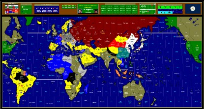
Update on the main map
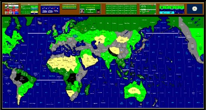
Terrain Map of the same
1940 Map; should USA be in yellow?
[attachment deleted by admin]
-
Why are you considering changing US to yellow?
Yeah I like getting rid of yellow neutrals. Yellow is a sharp colour not suitable for neutral imo.Oh and why do you give each country a (what are they called?) radial?
By the way, I thought Chinese Communist forces pre-1945 were only Guerillas.
-
It was just a crack about the US still being neutral. Hint - British irony.
I put the air force insignia for every air force active at the time on my maps. I just think it adds some colour, and after all there’s no real point in the original 5 “capital” roundels.
The distinction between Communist “Guerillas” and Nationalist “Regulars” is not I think so clear. The Communists or their Soviet-backed warlord Allies did control most of northern China. Certainly the influence of the KMT in these areas was negligible. And since the CCP can only raise infantry units anyway does the distinction matter that much?
Suggested Topics

