


@Imperious-Leader I live in central Missouri… I’m just going to a gaming con in Tulsa in February
Axis and Allies Complete
-
Latest stuff:
1945

The Yellow Peril

-
Haha I like the Free Masons symbol over DC
-
More stuff
February 1940

December 1941

December 1942

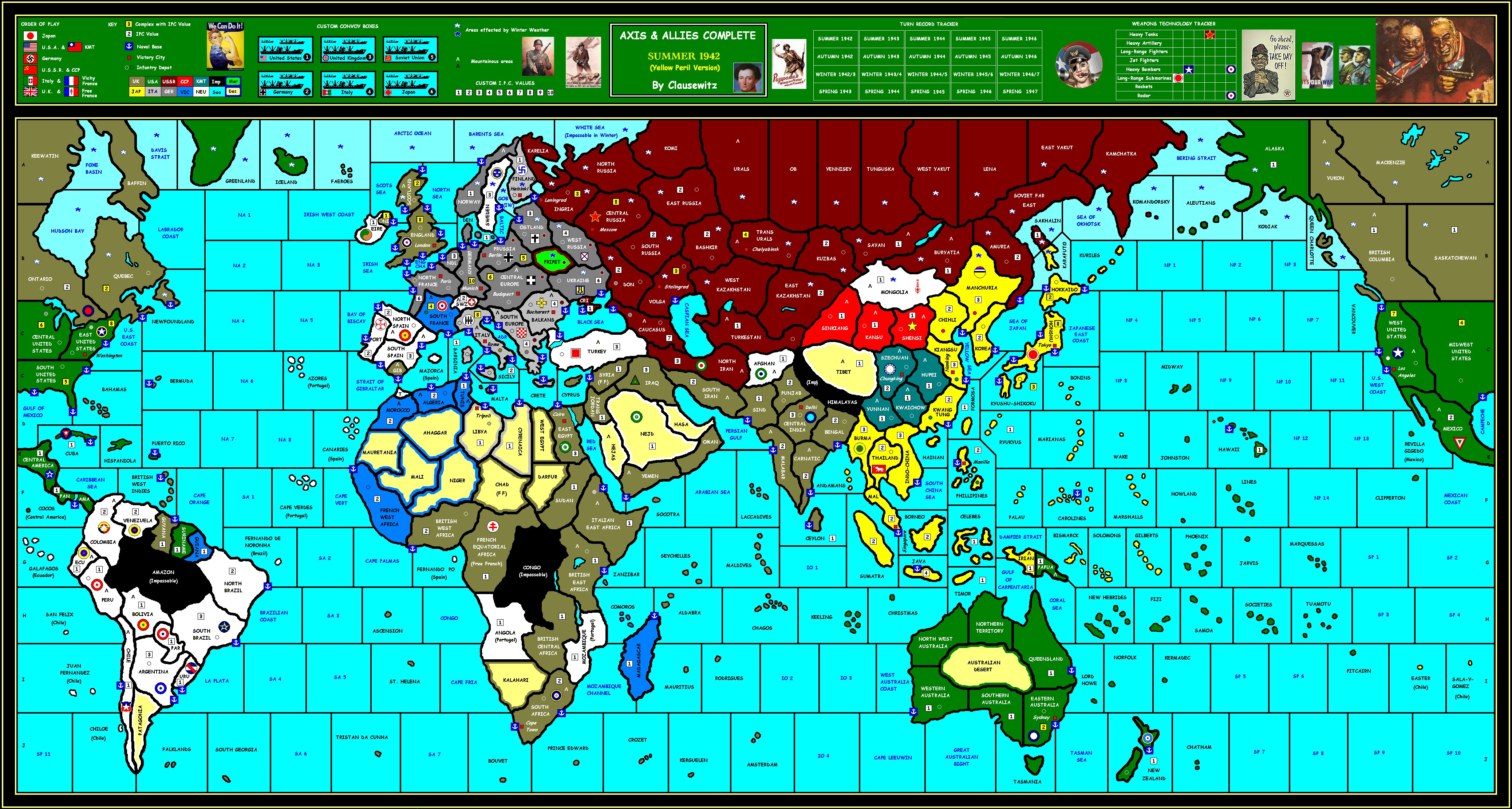
June 1942 - a simplified version without all the clutter so the likes of IL can understand it.

-
All i can say is……
^^^^^^^^^^^^^^^^^^^^^^^^^^^^^^^^^^^^^^^^^^^^^^^^^^^^^^^^^^^^^^^^^^^^^^^^^^^^^^^^^^^^^^^^^^^^^^^^**
-
And Behold!
Flashman posted his latest map and God saw that it was good.
http://www.boardgamegeek.com/file/26249/A&ACompleteJune1942V3simplified.PNG
-
Your new map looks better. Looks like you put a lot of work into it.
-
Is there a reason you didn’t call South France Vichy?
-
I prefer general geographical/demographic terms to political terms, so no “Vichy France” nor any “Nazi Germany”. Vichy was called this only from summer '40 to november '42 when the Germans moved in. Nevertheless it follows the same borders; the Germans deliberately drew them so that the entire Atlantic coast would be German occupied. Note that point, mapmakers.
Also, I don’t like naming territories of hundreds of square miles after a single city. I stand to be corrected, but you won’t find any on my map.
Canton, by the way, is the western name for the large region in south China as well as it’s principle city. It’s also a major language “Cantonese” so this is acceptable.
Gibraltar cannot really be called anything else, and the territory it represents is only the size of a city anyway. -
I prefer general geographical/demographic terms to political terms, so no “Vichy France” nor any “Nazi Germany”. Vichy was called this only from summer '40 to november '42 when the Germans moved in. Nevertheless it follows the same borders; the Germans deliberately drew them so that the entire Atlantic coast would be German occupied. Note that point, mapmakers.
Also, I don’t like naming territories of hundreds of square miles after a single city. I stand to be corrected, but you won’t find any on my map.
Canton, by the way, is the western name for the large region in south China as well as it’s principle city. It’s also a major language “Cantonese” so this is acceptable.
Gibraltar cannot really be called anything else, and the territory it represents is only the size of a city anyway.But it’s not just called Vichy because of the city. That was the name of the country. Vichy France was a minor axis power although technically neutral. It wouldn’t be called Vichy just becuase of the city. The country itself has been changed to Vichy France. It should especially be called Vichy since it is an actual player in your game. And also even though the Germans occupied it in '42 it was still Vichy France till '44.
Also just my 2 cents the map is good but it seems cluttered. How do the ports work? Like Pacific or some way else. What is the point of 2 in the Danish Sea? I don’t like the abbreviated things. Eng Cha looks ugly. Ndl for Netherlands? If you can’t fit the name of the country in the space maybe you should combine it with France. If things don’t fit either reduce the size of the font or label the sea zones by #. The yellow IPC values are IC’s right? No IC in Italy? Australia controlled by the USA? Should be under the UK banner or a separate power. This really cuts down any UK involvement in the Pacific War. Too many cluttering meaningless islands. How far does your fighters fly in your game? You can’t even fly a fighter from the USA to Hawaii its 5 spaces. That doesn’t seem right on a gameplay level. Sorry if I said too much. I don’t want to offend you. Those are just somethings I thought about it. There are many good things that are superior to the Revised map. -
Some things I really liked about your map. :-D
1.The spearated China-Represents history more.
2.North Africa-Allows for more see-saw battles with more spaces. Vast improvement over AAR and AAE. They really cheated it in AAE with one space for Libya and Eygpt.
3. Pripet Marsh
4.Moscow in Europe not in Asia
5.Neutral Powers
6.Minor Axis Powers-Definitely needed.
7. Soviet occupied Iran-More historical
8.Other things too but, I am sleepy.
-
I welcome your comments, good and bad.
Italy should of course have an IC. This is a mistake I made while simplify the map, even though you say it’s still cluttered!
I’m not sure Vichy France ever called itself that, but you may be correct. I’ll look into it.
The ports are Naval bases and are the only place damaged capital ships can repair. They also help with movement insofar as it cost no mps to move into/from a port, therefore ports which border 2 szs can be used to “jump” a sz. They therefore play a vital role in my naval refueling rule, which requires every ship to dock in a friendly port to refuel every turn. (Though my proposed tanker piece can be used to bypass this). I’m also considering that ships can only be constructed at NBs, only one per turn per NB; OR they are built at the IC itself, then launched at the NB the following turn. Finally ships can take refuge in NBs giving them protection against enemy attacks, rather than having to stay at sea every turn, which leads to the unrealistically high loss rate of fleet in the early rounds under standard rules.
I’m not keen on abbreviating titles myself, but on a map which has to be readable at a glance I don’t want to use tiny fonts. Maybe I’ll rename all szs by number in future.
I deliberately wanted wider oceans to make naval combat more significant. Perhaps the USA-Hawaii gap is too wide, I’ll look at this again. One effect of having wider oceans is the increased importance of small islands as naval/air stops/refueling bases. Places like St. Helena or Midway are of course economically worthless but can be logistically vital. Perhaps I have overdone them here, but at least it gives authentic names to sea zones rather than another sz number…
The US Australia thing is correct for Summer 1942 onwards. By that time the Allies had agreed to the US taking complete command of the entire Pacific war, including the armed forces of Australia and New Zealand, while the UK dealt with things in the India Ocean. Australian units from here on were under effective command of MacArthur’s SWP Command:
http://en.wikipedia.org/wiki/South_West_Pacific_Area_(command)
Gameplay wise this has several effects.
As you point out this excludes the UK from the Pacific, however in most games the UK tends to abandon the area anyway in favour of more critical theatres such as North Africa and India/Burma.
With the US in Australia, the importance of the Pacific theatre can be boosted because:
Sydney is now an American VC AND has a (2 unit/turn) IC, making it the closest US production centre to Japan. This makes it much more important than in Revised, and worth fighting over for both Pacific powers. The likely combat in this region is therefore entirely authentic, witness the Coral Sea and New Guinea campaigns.
-
You are correct about the USA-Hawaii problem, this has been corrected.
Regarding France, the Vichy regime simply called itself “The French State”, with the South/East area the “Free Zone”. “Vichy France” was a derogatory name used by the Allies, so I’ll stick with the neutral South France for now.
http://en.wikipedia.org/wiki/Vichy_France
Corrected simplified version:
http://elbowmaster.com/web1/flashman/1942/CompleteJune_1942simplified.jpg
And the more “cluttered” complete version:
http://elbowmaster.com/web1/flashman/1942/CompleteJune_1942.jpg
-
I was wondering why there is no Impassable terrain in the Saharra. I love the map, though, good work.
-
It was possible to cross the sahara from south to north. A small force of Free French from Equatorial Africa drove north through the desert to attack Axis outposts in Libya.
Can’t see this being done across the Himalayas, but just possibly the Amazon and Congo.
There are plenty of desert territories in the Sahara, but I’ve yet to decide just how they work. Perhaps a unit limit? This is complicated by making Libya and West Egypt desert, which is true enough for the terrain, but of course the forces in this campaign were supplied by sea.
Also considering Sinkiang, Kansu and NW Australia as deserts; the final decision on these depends on exactly what desert rules I adopt.
-
Update with improved Africa:
-
Yeah its hard to decouple rules and map.
But must try to decouple or things go around the circle.By the way, I find your continent lines fairly accurate.
(Was checking it against the 8MB earth lights map.)And are you using vector drawing?
-
To be honest, I made the mistake of starting with a scan of World at War. That put me wrong in so many ways the map has had a painful evolution. Several times I’ve had to cut out whole sections and relocate them, and add strips of map in three places to get the oceans an accceptable width. Most of the coastlines have been redrawn several times.
Tip: get the outline right before you do anything else!
What are vectors? I just use paint.
[attachment deleted by admin]
-
Paint works with pixels. Vector works with objects.
So with vector you can have shift things around very easily. Continents, names, and icons are all separate.
Also, vector is scalable. No pixelation when enlarged.
By the way, use gif instead of jpg for textureless maps (and cartoons). Its actually smaller yet lossless compression.
-
I actually send the maps to Elbowmaster as PNGs, so as he’s hosting them it’s his decision to use Jpegs, which admittedly blurs the images.
This board doesn’t allow Gifs, by the way.
[attachment deleted by admin]
-
Finally answer C. pretty colours. reminds me of LSD. :mrgreen: :lol:
Suggested Topics

