


@The-Captain It never fails to amaze me just how many house rules you’ve managed to come up with for this game. Great work!
A plea for originality in mapmaking…
-
I’m a little surprised at all the intense work that people do here making new maps, but they are made exactly like official maps - even down to the letter font used.
Take the Europe and Pacific 1940 official maps, for example. These are treated by some mapmakers as a scribe would the Holy scrolls of law handed down by Moses - one jot or tittle cannot be changed! Yet these maps were made by people who were under a deadline and trying to get a product out to make a profit. Did they love WWII history like we do? Do they themselves obsess for hours over Axis and Allies strategies like we do? Or was their priority to get a shipment out? Was Axis and Allies just another game to them amongst shelves full of fantasy and futuristic stock to move?
Could someone who genuinely loves history and loves Axis and Allies make a better map than those sold? I say emphatically YES! Here’s a few examples from the 1940 maps I’ll show you:
Below is the Burma Road on the G40 Pacific map. But actually this shows the Ledo road going into India. This road going to India didn’t even open until 1945.
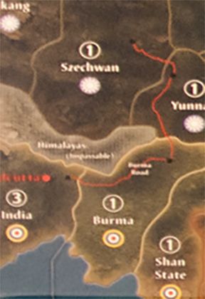
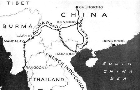
The Burma road connected with a railroad that went down to Rangoon, in Burma, like this.
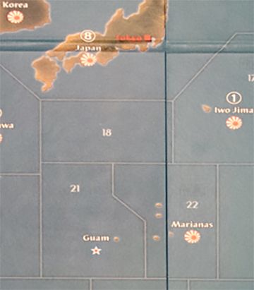
This part of the G40 Pacific map shows the Marianas and Guam. Guam is actually South of the Marianas, not West, and is part of the Marianas Island chain. Tinian Island is part of the Marianas. From Wikipedia “Immediately after (Tinian’s) seizure by the United States, construction work began on the largest airbase of World War II……this base was a 40,000-personnel installation.” So Tinian was THE island to have in WWII to make heavy bomber strikes against Japan. Yet on this map is it too far away. Iwo Jima is actually better on this map for a bomber base, even though it was only used for emergency landings in WWII.
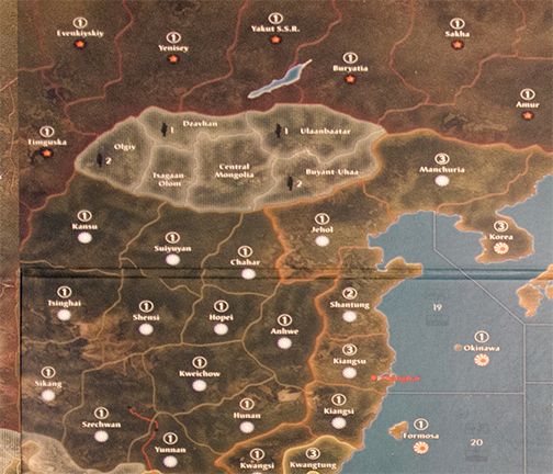
This part of the G40 Pacific map shows Russia, Mongolia and China. Look how huge Mongolia is. And with its texture and lighting, Mongolia is the first place your eyes go - yet Mongolia is a neutral! Why does a neutral have 6 territories and looks like it is the featured country in this theatre? Then look - these remote rugged areas of Russia and Western China are all worth 1 IPC each - the IPCs work like bread crumbs that lead Japan straight to the backside of Moscow. Actually Japan had no intention of going to Moscow - they knew the terrain was horrible and their units already performed badly in earlier border skirmishes with Russia. Japan historically chose the Southern Expansion Doctrine (Nanshin-Ron) for their war policy throughout the war.
A more sensical map would put a bunch of 0 IPC territories between Moscow and Japan, to discourage Japan from going there.
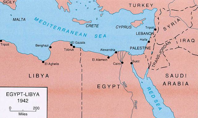
Here is Egypt on the G40 Europe map. You have control 2 different territories bordering the Suez canal in order to use it.
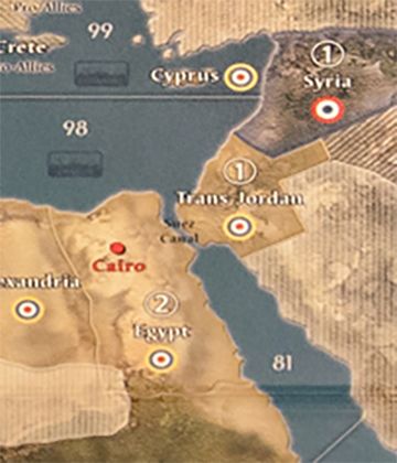
But just by Googling Egypt in 1942 you can see that the Suez canal only goes through Egypt itself.
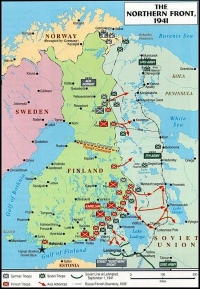
Finally, here’s a shot of Finland on the Europe 1940 map - look at Finland - it appears possible to access Finland from the North Sea and thus do an amphibious assault there:
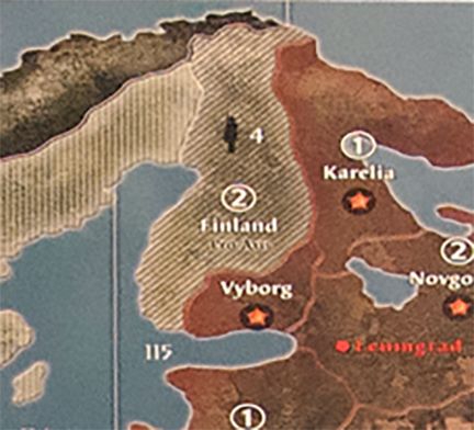
But by looking at a map of Finland from that era you can see that there is no access to Finland from the North Sea - Norway covers it.
These are just a few examples of the vast room for improvement these official maps leave.
In no way did I write this post to slam the official maps - I know that players have invested many hundreds of hours enjoying them and no doubt feel a sentimental attachment to them.
The purpose of this post is to encourage the many talented mapmakers out there to get creative and do BETTER than the official maps. You have no time constraint - no boss. You have your love for history and love for this game - why just stop at making a copy of what’s already done?
Make us a masterpiece!

-
Like this.
.png)
-
Burma Road ?
.png)
-
No Guam on this map. So don’t know if this is what your kinda looking for. This is the 40 map I use.
.png)
-
Der Kuenstler :
The map cant look real because if you haven’t noticed the OOB map was made to be playable in Europe, otherwise even an 8 foot map would make the pieces crowded and the map would be 3 times taller to accommodate the ratio that Africa represents to Europe. Also it would be alot longer to accommodate the American continents and the actual expanse of the pacific. Its no time to gripe about such things, AA games have always done these things so the game would be playable in the areas where it counts, not Mongolia, but between Paris and Moscow.
Buy an actual real world map and see the problems with playing this type of game on it.
The font is important because its OOB and people want OOB style. They don’t want kaka. The Burma road could be altered as long as it runs thru the same areas on the map. These people who make such things consider the very people who will use them and they make them larger so you can play the game that was made from other peoples time, whom carry the passion forward with no reciprocation in mind and some quantity of effort and care to benefit others and themselves when they play.
IPCs work like bread crumbs that lead Japan straight to the backside of Moscow.
You latter answered your own question. They are worthless because they are, and additionally because they want to discourage that Japan tank drive thing from revised ( which is why nobody with sense plays that version anymore)
The map has to be that map or were talking about a different game.
-
What map is that, SS?
-
@Imperious:
The map cant look real because if you haven’t noticed the OOB map was made to be playable in Europe, otherwise even an 8 foot map would make the pieces crowded and the map would be 3 times taller to accommodate the ratio that Africa represents to Europe.
Yes I know there will be distortions for gameplay purposes - after all we are pushing carriers around the size of Italy. I have no problem with Europe being larger and such - it can’t look absolutely real but it can still play out a lot more real with smarter arrangement of borders and even a casual look on the internet, as I’ve shown with some examples.
The map cannot be why we call it Axis and Allies as there have been how many different “official” maps since 1984? 16? And how many different fonts on those maps since then?
SS those shots look like a few issues were addressed…
-
What map is that, SS?
http://www.historicalboardgaming.com/Global-War-1939_c_170.html
Looks like that one, or a variant of it.
I prefer maps like those, where the overall look is more political than topographical, since they remind me a bit more of Classic than the more recent A&A boards.
Going that route though it is probably difficult to please everyone with the color choices (take Revised as pretty extreme example of a color scheme that still strikes me as pretty garish.)
I tend to dig something with a more mid-century aesthetic, that recalls maps like this one… (attached a thumbnail below.)
http://www.davidrumsey.com/luna/servlet/workspace/handleMediaPlayer?lunaMediaId=RUMSEY~8~1~272368~90046165There are some pretty cool image ideas in that stanford collection, if you just randomly search around for WW2 stuff hehe…
http://www.davidrumsey.com/luna/servlet/view/all/what/World%2BAtlas/when/World%2BWar%2BII?sort=Pub_List_No_InitialSort%2CPub_Date%2CPub_List_No%2CSeries_NoFor font choices, again, I’d go with period stuff more like this…
http://www.1001fonts.com/1940s-fonts.htmlThose are mainly aesthetic choices, finding a functional world projection is clearly more challenging. A&A is considerably more distorted than Mercator, which already heavily warps the world to make Europe appear larger than it is in reality. Basically you have too big balloons, one on Europe and one on the South Pacific, everything else has to twist and bend to make those regions work.
It’s a bit unfortunate that no one has yet explored micro-sculpts for A&A. 1/72 seems to be as small as we can go, and still have units to play with, so the map needs to accommodate those. And Maps like G40 or Global War, have more unit types in the roster, which increases the potential for crowding on a given tile.
Anything larger than 6 feet becomes completely impractical for me. 8 foot tables are just too hard to store, and a map that large would be too expensive to print and hard to find room for in the house. Even at 4-5 feet, I still need a second pop up table to handle all the rest of the stuff like the bank, unit trays, rolling, room for snacks and drinks etc. Maybe in other places where housing isn’t so insane people have more room for this stuff, but where I live, a map like G40 is dominating literally the entire living space hehe, which puts limits on how long I can leave it up.
So given that you really have to make it in under 72" that means you need to distort the hell out of Europe and the South Pacific relative to the rest of the world to make it fit the desired playscale. I don’t know that there are whole lot of tricks left in the bag that one could try, that haven’t been tried already in terms of distortion. But I will say, just from tripleA experiments, I think it is helpful if you start out with a map that has many more territory divisions than you actually need, and then remove these after the map is warped (not before warping). That way you can still tell what’s going on after it’s stretched (even when you don’t preserve the aspect ratio.) To help avoid unnecessary territory blobs, or the situation where rivers and borders, just become random arbitrary “squiggles” when redrawing them after the warp.
This is crude (using one of my tripleA baselines) but you can see what I mean. Even after I stretch horizontal by 200%, I can still tell roughly where things would need to be. The original is already highly distorted, but using that a foundation that is all carved up, I can stretch and then collapse the borders I don’t need, and still end up with shapes that have some kind of relative consistency, and less chance that something ends up totally out of place, or reshaped in a way that allows for bizarre connections.


-
The font should be easy to read - I will say that about it. I’ve tried using a 1940’s typewriter font for territories, and it did have a cool authentic look, but it was hard to read from a few feet away. This is a game map and the map creator is constrained in that people have to be able to easily play a game on it, or it has lost its purpose.
-
Looks like that one, or a variant of it.
You’re right! I have an earlier version. I didn’t know they’d revised.
Those are mainly aesthetic choices, finding a functional world projection is clearly more challenging. A&A is considerably more distorted than Mercator, which already heavily warps the world to make Europe appear larger than it is in reality. Basically you have too big balloons, one on Europe and one on the South Pacific, everything else has to twist and bend to make those regions work.
What about insets around the edge of the map? The Big Game does that, and it addresses some of the problems of clutter while allowing a more accurate topography.
Another option, of course, is to restrict the map to Europe, North Africa, and things east of Suez, west of San Francisco, and north of Darwin, Australia. You effectively do away with central and southern Africa, Central and South America, and the southern Indian Ocean.
It all depends on whether somebody wants to play a simulation of the Second World War that follows the historical path more or less precisely, and whether somebody (like me, for instance) is interested in seeing the game expand to other fronts, such as South America.
It really is indeed all about table size. I purposely chose a living space that could accommodate a very large table, with inserts.
-
No the map is Death heads 40/41 map it’s the map I use for my 40 game. Map file is in Global War thread page 1. This is the map that HBG took and changed . Tigermans 39 map looks all most like it. Then HBG changed things and came out with there 39 1st edition map. They used DHs map for a template.
-
Ah, I see. Thanks much!
Those maps are all gorgeous.
-
Der Kuenstler,
My guess is that most people here want to play A&A (like IL mentioned), not a realistic WW2 game. If you wanted realism, you would have probably already switched to Global War 2nd edition…
Note that most (all?) of the issues you mention have been fixed on HBG’s “Global War 1936-1939, 2nd edition” map:
http://www.historicalboardgaming.com/Global-War-1936-1945-Variant-Map_p_2029.htmlTake a look, it’s quite good.
-
On 1914 the borders of Poland and Bulgaria are incorrect, partly because they obviously based the map on Diplomacy rather than a real map of Europe in 1914.
Moscow being placed in Siberia is another howler from many of the earlier versions; though acceptable for some for game balance reasons. Personally I prefer to play on a map that looks something like the real world, though shrinking and expanding some areas is always needed - the curve of the earth means there is no definitive flat world map in any case. But China on the A&A global board does not bear any close comparison with a real map.
The Suez mistake was corrected for the 1914 game. But it’s amazing how many amateur map makers treat official A&A as gospel and repeat the same mistakes rather than researching their own history. Just where is Rio de Oro again? When did Brazil declare war?
I’ve even seen some purported WWII maps include such territories as Bangladesh & Pakistan! FYI New Delhi replaced Calcutta as the capital of British India in 1911.
Another thing I dislike is the Gibraltar territory. For the sake of having this in the game as a vital port a ridiculously large “bite” is usually taken out of Spain. I prefer that Gib is considered as a “Treaty Port”; that is the UK/Allies have use of Gibraltar as a port but it is considered part of neutral Spain. In order to attack Gibraltar the Axis have to conquer Spain itself in which case the port becomes Axis controlled as part of that tt.
Japan attacking Moscow from the east is the single thing that does most to kill the feel of A&A being a WWII game - it sets events in an alternative reality in which Japan risked war with America without securing their backdoor with a Soviet non-aggression pact, and in which Stalin would get involved in fighting Japan before the German war was won. If you want a Pacific war, and Russia having a chance of surviving, then some form of Russo-Japanese pact is a must.
-
Note that most (all?) of the issues you mention have been fixed on HBG’s “Global War 1936-1939, 2nd edition” map:
http://www.historicalboardgaming.com/Global-War-1936-1945-Variant-Map_p_2029.htmlThere is a lot to like about this map, for sure!
-
FYI New Delhi replaced Calcutta as the capital of British India in 1911.
I wonder why they kept it as a capital there - maybe so they could keep a victory city on the Pacific side of the map?
Another thing I dislike is the Gibraltar territory. For the sake of having this in the game as a vital port a ridiculously large “bite” is usually taken out of Spain. I prefer that Gib is considered as a “Treaty Port”; that is the UK/Allies have use of Gibraltar as a port but it is considered part of neutral Spain. In order to attack Gibraltar the Axis have to conquer Spain itself in which case the port becomes Axis controlled as part of that tt.
A mutated Gibraltar has never really bothered me - it is in the right historic spot and its larger size shows its importance and makes it practical for use within the game. It was so well protected that requiring Spain to cooperate in order to get it would probably be a good house rule, though.
Japan attacking Moscow from the east is the single thing that does most to kill the feel of A&A being a WWII game - it sets events in an alternative reality in which Japan risked war with America without securing their backdoor with a Soviet non-aggression pact, and in which Stalin would get involved in fighting Japan before the German war was won. If you want a Pacific war, and Russia having a chance of surviving, then some form of Russo-Japanese pact is a must.
Yes and double yes! We veteran AA players can all remember attacking Russia with Japan and thinking “Why didn’t Japan do this historically? I must be a genius!” But the real answer is, comparing the actual manpower and equipment of the two nations, and the logistics involved crossing thousands of miles of undeveloped territory to reach Moscow, it was just not possible.
-
My guess is that most people here want to play A&A (like IL mentioned), not a realistic WW2 game.
To a certain extent that’s true, in the sense that playing A&A means accepting that the game has a lot of simplifcations, rationalizations, and a few clunky solutions to some WWII elements that are admittedly awkward to model in a board game of A&A’s general type. That being said, I think a distinction can be made between A&A game elements that require a suspension of disbelief and A&A game elements that (arguably) require a suspension of rational thought…a good exmaple of the latter being the Japanese overland drive towards Moscow that Flashman and D.K. have just commented on.
-
At the other extreme it’s been pointed out that Axis and Allies as a pure “game” could just as easily be played on a chessboard.
The map is the thing more than anything else that draws me towards a game. If it doesn’t look like a real place I’m not going there. If it shows Vikings with horned helmets it goes straight back on the shelf.
-
The map is the thing more than anything else that draws me towards a game. If it doesn’t look like a real place I’m not going there. If it shows Vikings with horned helmets it goes straight back on the shelf.
Speaking of Vikings and of eyebrow-raising map conventions, have a look at the board for the 2004 game “Fire & Axe: A Viking Saga”
https://www.boardgamegeek.com/image/186332/fire-axe-viking-saga
Part of the map is fairly realistic, but the parts that depict central and eastern Europe are staggeringly distorted: the rivers in the region are expanded and consolidated into a single waterway that’s wider than the English Channel and that runs nearly all the way from the top of the map to the bottom, with the result that Russia practically becomes a separate continent. If this board was being used for an A&A game, Germany would have the option of launching two Sea Lion invasions: one against the UK and one against the USSR.
-
Wow that’s crazy - I guess I could get used to it - but it looks like on that map you could sail clear from the Baltic to the Black sea - is that even possible? See I don’t mind distortions for needed space as long as they still respect historical reality.
Suggested Topics

